Possibility of snow lingers in Western Washington’s forecast
Feb 17, 2019, 8:11 AM | Updated: Feb 18, 2019, 1:00 pm
(National Weather Service)
(National Weather Service)

Even with piles of sandy, crusted-over snow still trying to melt, snow is once again in the forecast.
RELATED: National Guard sent to aid North Bend socked in by snow
RELATED: Should Seattle rethink its plans for snow plows?
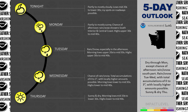
As clouds increase Monday night into Tuesday, KIRO 7’s meteorologists say moisture could return in the form of light rain or snow showers. But warmer temperatures may prevent snow from reaching sea level on Tuesday. Accumulations would be light. The National Weather Service says the best chance for accumulation is in areas near Bellingham.
Meanwhile in North Bend, a city where the National Guard was recently sent in to help with snowstorm fallout, snow has returned at around 500 feet of elevation. KIRO 7’s Nick Allard says that snow levels will stay at around 500 to 1,000 feet there for “the next few days.”
KIRO 7 reports the better chance for snow is Tuesday night into Wednesday morning as the moisture level is significant enough. If the temperatures are cold enough, that system could produce a few inches of snow for areas above 500 feet, according to KIRO 7.
The NWS predicts snow levels at 500 to 1,000 feet on Tuesday, with “a few snow flakes mixing in with the rain below 500 feet.” Wednesday, it calls for “a few spotty showers with snow levels around 500 feet.”
Passes during that period will likely experience heavy snow.
The NWS says a convergence zone on Wednesday morning could result in snow, but it’s not yet clear the location and accumulation levels.
The temperatures will remain cold enough for snow around the lowlands through the rest of the week and likely the week after, according to KIRO 7. The National Weather Service says temperatures could remain 5-10 degrees below normal in late February, putting us on track for one of the coldest Februaries in decades.
The NWS says there’s another possibility of snow on Friday into Saturday.