The mountains of Arunachal, where an IAF AN-32 plane crashed, has long been a danger zone for aviators.
Wreckage of the AN 32 that crashed on June 3 en-route Mechuka was found in Pari Hills of Siang district after eight days of extensive search in a 1,000 sq km area.
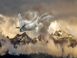
The AN-32 crash in Arunachal Pradesh has become another grim reminder of the reality that flying over the mountainous state continues to be fraught with risks. For World War II pilots, this eastern Himalayan region was the “Skyway to Hell” and despite advances in flight technology since then, the stretch of deep valleys and high mountains is still one the deadliest flight routes in the world.
And once a plane goes down, the dense foliage and cloudy hills make it hard to even find the wreckage, as was the case with the Indian Air Force transporter en route from Jorhat in Assam to Mechuka in Arunachal Pradesh. The plane with 13 people on board remained missing for eight days.
The wreckage was finally spotted on Pari Hills in Siang district. When rescuers managed to reach the crash site, at a height of nearly 12,000 feet, they found no survivors.
AVIATION CHALLENGES Thick cloud form by 1 pm, particularly in pre-monsoon season. Rapid changes in weather coupled with occasional strong winds. Rugged terrain, deep gorges and steep valleys rising above 10,000 ft Low population density, poor road network hamper search operations.
Crashes in Arunachal 13 Air crashes since 1995* including 2 AN-32s and a Su-30 10 of these are chopper crashes 106 No. of deaths (including that of Arunachal CM Dorjee Khandu), due to these crashes 594 No. of Allied forces’ aircraft that crashed in “the Hump”. The area comprises of today’s Arunachal and parts of China and Myanmar 81 No. of Allied aircraft that are still missing 345 No. of people, mainly from the US, listed as missing in these crashes *Data for accidents between 1947 and 1995 are not available Source: Ministry of Defence, news reports, Defense POW/MIA Accounting Agency, US
Once Upon The Hump Flying over the unforgiving eastern Himalayas has often been tragic.
In April 1942, when the Japanese Army blocked Burma Road (the 1,150-km mountain highway between Lashio in present-day Myanmar and Kunming in China), US-led Allied forces had to undertake arguably the biggest airlift in aviation history. For the next three years, the C-47, C-46 and C-109 planes transported nearly 650,000 tonnes of supplies (fuel, food and ammunition) from airfields in Assam to those in Yunnan, China.
The Allied pilots nicknamed the route as “the Hump” because their aircraft had to navigate deep gorges and then quickly fly over mountains rising beyond 10,000 feet. “The Hump” is none other than today’s Arunachal Pradesh and parts of Myanmar and Tibet. Over 650 aircraft crashed in “the Hump”, killing more than 1,000 fliers, mostly pilots, according to Lt Gen William Tunner, then commanding the US Military Air Transport Service.
Also, 81 aircraft went missing in the region, with searchers failing to spot any wreckage. It took around 70 years before the debris of two such planes — a C-109 from Jorhat to Hsinching and a B-24J from Kunming to Chabua — was spotted in the hills of Arunachal by trekkers and villagers.
13 Since 1995 Planes may have become more advanced, but this region’s rugged terrain and severe weather conditions remain the same as they were during World War II.
Based on readily available data, Arunachal Pradesh has witnessed 13 air crashes since 1995. This included 10 choppers, two AN-32 transporters and a Sukhoi Su 30 fighter jet.
Plane accidents in the state before the 90s were rare since there was hardly any aircraft activity in the mountainous north. After the Allied airlift ended in 1945, there was no urgency for planes to fly over “the Hump”.
Even the IAF, till about a decade ago, had restricted flights over this region till 1 pm because of rapid formation of thick clouds in pre-monsoon days along with other weather hiccups.
But with the Chinese military aggressively strengthening its airbases on the other side of the McMahon Line that demarcates China and northern Arunachal Pradesh, New Delhi shed its complacency.
The government soon handed over eight strategic airfields in Tuting, Mechuka, Aalo, Tawang, Ziro, Pasighat, Walong and Vijaynagar to IAF for upgradation. That was a decade ago.
By then, the IAF also began flying in the evening and also experimented with limited night sorties.
To Stay Out of Danger Commercial flights in Arunachal Pradesh first started in the mid-1980s when state-run Vayudoot Airlines (now defunct) flew 19-seater fixed wing aircraft to Pasighat and Ziro. But operations were abandoned mainly because the airline could not recover costs.
Then last year, when Air India subsidiary Alliance Air started flying a passenger plane (a 46-seater ATR 42) to one of the upgraded airfields — the Advanced Landing Ground in Pasighat, the issue of safe landing was made top priority.
Navigational aides were installed; some trees near the airfield were uprooted and drains along the runway were covered to enhance safety, Alliance Air CEO CS Subbiah had told this writer in May 2018.
The government is now looking at expanding civilian air operations to Arunachal Pradesh’s other airfields under the regional air connectivity scheme called UDAN. State capital Itanagar however does not have an airport yet.
But landing in Ziro or Pasighat located near the plains of Assam is easier than landing in high-altitude Tuting, Mechuka or Walong located near China.
Air Marshal Pranab Kumar Barbora, who retired as vice chief of air staff in 2010, has the distinction of piloting all types of military aircraft in Arunachal. He says flying over the state’s mountains has three challenges: the weather, the terrain and technical issues. “If weather is coupled with terrain or technical (issues) is coupled with either terrain or weather, it’s difficult to stay out of danger,” he told ET Magazine.
Due to these factors, IAF does not allow new recruits to venture into valley flying (with mountains on both sides) in Arunachal Pradesh, he says.
In May 2008, Barbora flew an AN-32 to Daulat Beg Oldie airstrip located at a height of 16,614 feet in Ladakh and vouched for the technical robustness of the aircraft. But he also said that the transporter was unsuitable for flying at extreme heights.
“IAF has now begun to procure powerful planes,” he said. “For example, the C-130 Hercules has four engines (as against two in AN-32). In case the pilot suddenly finds himself flying towards a hill, he can make a steep ascent in a C-130. An AN-32 cannot do that.”
We do not know yet why the AN-32 crashed on June 3 since its black box was recovered only on June 13.
Siang deputy commissioner Rajeev Takuk was at the base camp of the mountain on which the plane crashed when he spoke to ET Magazine on the phone. He said: “Weather and terrain are the main challenges for the rescue team. The crash is on a hill. One has to trek for a day from the nearby village of Gate [pronounced Ga Te]. We sent five mountaineers, Tekseng — had climbed Everest last year.”
Hard to Spot Planes Since the plane was missing for days, is it not odd that no one in the villages saw it fall out of the sky since the crash occurred in the afternoon? Actually not.
Arunachal Pradesh has a low population density — 17 people per square km against the national average of 382. Gate — the only village in the vicinity — has just 256 residents, according to the 2011 Census, making it unlikely that anyone noticed the crash.
Then there would have been clouds. During the ongoing pre-monsoon season, ground temperature in Arunachal rises quickly to 28-30 degrees Celsius, and by noon, the sky is covered in thick clouds, say weather experts.
Pilots can usually take their planes out of non-communication zone in the gorges provided there is visibility.
The AN-32 went off the radar at 1 pm, never to regain connectivity. The crash site is slightly off the usual flight path.
So when a plane falls off the sky on a cloudy day, there are chances that villagers would not notice. That is why it takes days and even years to find the wreckage.
On April 30, 2011, when a Pawan Hans EuroCopter B8 chopper carrying Arunachal chief minister Dorjee Khandu and four others went missing, its wreckage was spotted five days later in Luguthang, also near the China border. There were no survivors.
Far Away from Roads This is the dilemma. While flying in Arunachal is risky, air connectivity is indispensable as road network is poor.
During the recent Lok Sabha elections, as many as 434 polling stations in the state could not be reached by roads.
In a booth in Cheppe village in Anini constituency, polling officials walked for five days, with night halts in Anelih, Thyee, Engalin and Awoka, chief electoral officer Kaling Tayeng told ET Magazine.
No wonder so many World War II aircraft are still missing in action in the peaks and valleys of Arunachal.
Memories of a Forgotten War — a 2016 documentary by Utpal Borpujari, a national award winner — ends with visuals of the wreckage of a US aircraft in the hills of Arunachal. “The story of World War II in the Northeast is not yet over. The Americans will continue searching for missing planes,” he says. two of them — Taka Tamut and Kison.
Lost & Found Jan. 25, 1944: B-24J bomber flies from Kunming in China on a mission to Chabua in Assam but goes missing with four other aircraft on the same route
2006: An American hiker spots wreckage of an aircraft near Damro village in Arunachal 2008: Indian government grants access to US investigators who confirm the wreckage is of B-24J
2009: Excavation does not lead to any conclusion about the crash
2015: Remains of victims recovered
Pilots Face 3 Challenges in Arunachal: Techincal, Weather & Terrain
Retired Vice Chief of Air Staff Pranab Kumar Barbora achieved the rare feat of flying an AN-32 to Daulat Beg Oldie airstrip at a height of 16,614 ft in 2008, reopening the airbase after decades. Barbora, who has also flown planes in Arunachal, told Shantanu Nandan Sharma how rapid weather changes, along with gorges and mountains, challenge pilots. Edited excerpts:
Others
How robust is the AN-32 aircraft? AN-32 is the workhorse of the Indian Air Force. It’s highly essential. We have more than a hundred of this aircraft which is used mainly for air-maintenance (ferrying of goods). But its load carrying capacity is on the lower side, about five tonnes or so. Yes, I flew one to Dawaltbaigh Oldi, but the aircraft is not suitable for such elevations. After all, it has only two engines. IAF has, however, started getting powerful planes now. For example, the C-130 Hercules has four engines. In case the pilot suddenly finds himself flying towards a hill, he can make a steep ascent in a C-130. An AN-32 can’t do that.
Having flown over Arunachal Pradesh for many years and knowing the topography well, what could be the possible reasons for the recent AN-32 crash? The reasons will be known only after an inquiry. My reading is it could be because of weather. The crash site is a little away from its flight path; so there could be other technical issues also. But there was no radio transmission about any technical problem. So, only a probe can put together all these pieces of jigsaw puzzle. So far as the 2009 crash of an AN-32 in the same area is concerned, it was found that weather and terrain lead to the crash.
Why is flying over the high mountains of Arunachal considered risky, right from the days of World War II? The planes used during World War II were archaic. Those were slow-moving propeller aircraft which could not climb very high and were highly susceptible to weather. A large number of aircraft vanished. But the Americans don’t forget their dead; so they try to retrieve the bodies even today. If locals or mountaineers spot any plane part, they swing into action and begin investigations.
The vegetation in Arunachal Pradesh is unbelievably thick. There are many areas where sunlight does not reach the earth. The undergrowth is even worse. When we lose an aircraft, which happened many a time, we always instruct the members of a search party to fasten themselves with a rope. Otherwise, there are risks of rescuers themselves getting lost.
So what is the main challenge — the terrain or the weather? In a hilly terrain like Arunachal Pradesh, there is high vegetation and high moisture. As the day gets hotter, thick cloud formation takes place. Earlier, we limited our operations to those areas till about 1 pm. If you can’t see what is ahead because of clouds, flying in that terrain is very difficult. There are high mountains all around. There are mainly three constraints — weather, terrain and technical. If weather is coupled with terrain or technical (issues) is coupled with either terrain or weather, it is very difficult to get out of danger.
But isn’t our inability to fly anytime of the day an issue when the Chinese are so active on the other side? As communication systems and other technology had improved, we were able to fly during afternoons and even at nights in Arunachal Pradesh. We formulated stricter standard operating process. About a decade ago, we developed limited night operations capability in and around Mechuka (that borders China). We had to do that as the Chinese bases came up right on the other side.
What was your first reaction when you reached Dawaltbaigh Oldi airstrip flying an AN-32? I was relaxed. I wanted to light a cigarette. But I could not. There wasn’t enough oxygen for me and the cigarette.


 Get Unlimited Access to The Economic Times