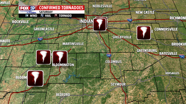
The Nation Weather Service has confirmed that six tornadoes tore through central Indiana Saturday.
Marion County suffered two tornadoes. An EF-0 tornado and an EF-1 caused damage in Beech Grove.
JUST IN: A @NWSIndianapolis storm survey found damage in Beech Grove to be caused from an EF1 #tornado. #INwx
Max Wind: 100 mph
Path Length: 1.86 miles
Path Width: 200 yards— John Dissauer (@johndissauer) June 16, 2019
Monroe County suffered damage when an EF-2 tornado ripped through Ellettsville.
JUST IN: A storm survey completed by @NWSIndianapolis finds damage near Ellettsville, IN was created by an EF2 #tornado. #INwx
Max Wind: 130 mph
Path Length: 3.7 miles
Path Width: 400 yards— John Dissauer (@johndissauer) June 16, 2019
Owen County saw an EF-1 tornado cut through the town of Freedom.
JUST IN: A storm survey completed by @NWSIndianapolis finds damage near Ellettsville, IN was created by an EF2 #tornado. #INwx
Max Wind: 130 mph
Path Length: 3.7 miles
Path Width: 400 yards— John Dissauer (@johndissauer) June 16, 2019
Green County experienced an EF-2 tornado that started in Koleen and ended around Solsberry.
JUST IN: A storm survey by @NWSIndianapolis finds damage in eastern Greene County was caused by EF2 #tornado. Tornado started near Koleen, IN and ended near Solsberry, IN. #INwx
Max Wind: 130 mph
Path Length: 3.52 miles
Path Width: 400 yards— John Dissauer (@johndissauer) June 16, 2019
NWS did confirm there was a tornado in Rush County, but they are yet to survey the area to determine the strength and path size of the tornado. There is a good chance that we will see this confirmed tornado rise in the coming days, as crews continue to survey Saturday evening’s storms.
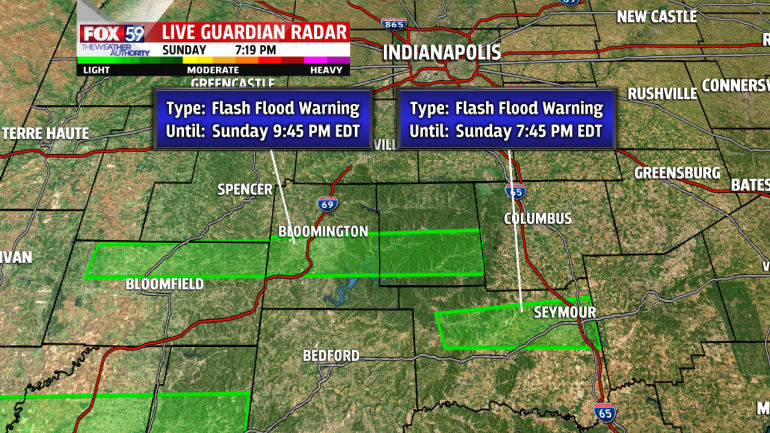
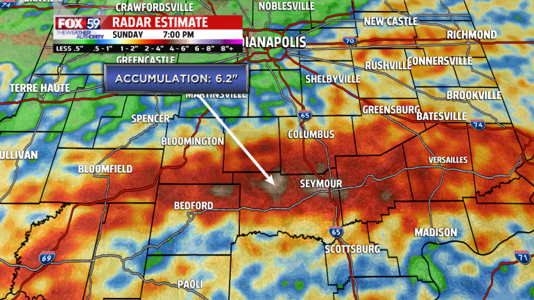
Sunday evening’s strong storm threat has now turned mainly into a rain threat for the rest of the evening. Heavy rain continues to pour over southern Indiana across already very saturated ground, prompting Flash Flood Warnings. Radar indicated rainfall is showing that some areas have seen roughly 6″ of rainfall, today alone.
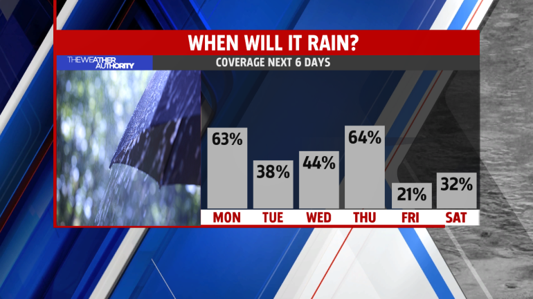
Daily chances of rain continue this week. We will find hours of dry time too. A few light showers will pass through early Monday morning, then we’ll see dry time by late morning into the early afternoon. However, rain and storm chances will return as we head into Monday afternoon. As we are still dealing with soggy soil across central Indiana, any heavy storms could quickly cause additional Flash Flooding events. Do not drive through flooded roadways. Most flood deaths occur in vehicles.