
Photos showed what might have been a tornado touching down in Harrisburg, Pennsylvania. You can see pictures of the possible funnel cloud throughout this article. However, the National Weather Service only has Harrisburg under a severe thunderstorm and tornado watch as of the evening of May 29, 2019. It has not confirmed any tornado touchdown in Harrisburg.
There was a tornado warning for Harrisburg, but it expired. “Tornado Warning including Harrisburg PA, Hershey PA, Colonial Park PA until 4:45 PM EDT,” the NWS wrote.
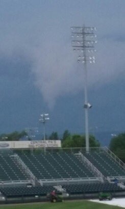
A few more viewer images of the possible funnel cloud or tornado just north of Harrisburg earlier this evening. The second picture was taken from city island looking north.

The severe weather in Harrisburg had people rattled after a series of dangerous tornadoes threatened other areas of the country, damaging communities everywhere from Ohio to Kansas. Why are there more tornadoes right now? You can read an analysis here.
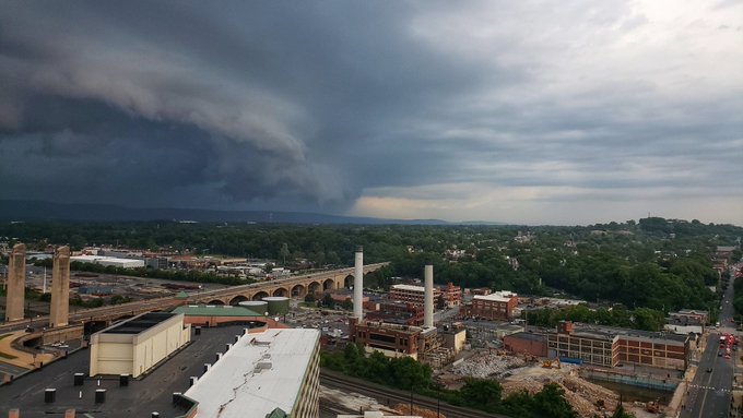
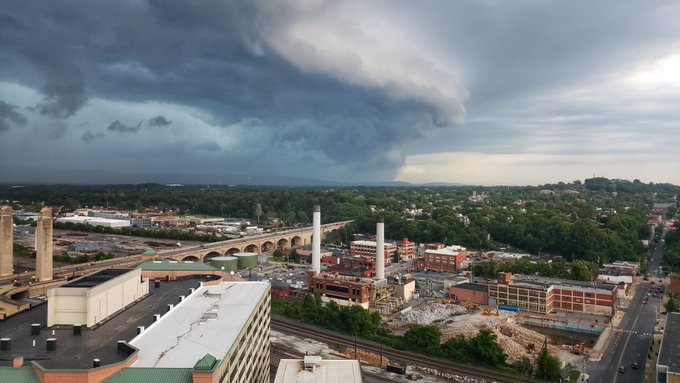
Shelf cloud a bit over an hour ago as a tornado warned storm moved over Harrisburg, PA. #pawx

The National Weather Service office in State College handles the weather for Harrisburg, PA. That office was still predicting that a tornado was possible but had not confirmed one’s presence. “Severe Thunderstorm Warning including Lancaster PA, Harrisburg PA, York PA until 6:45 PM EDT,” the most recent post read.
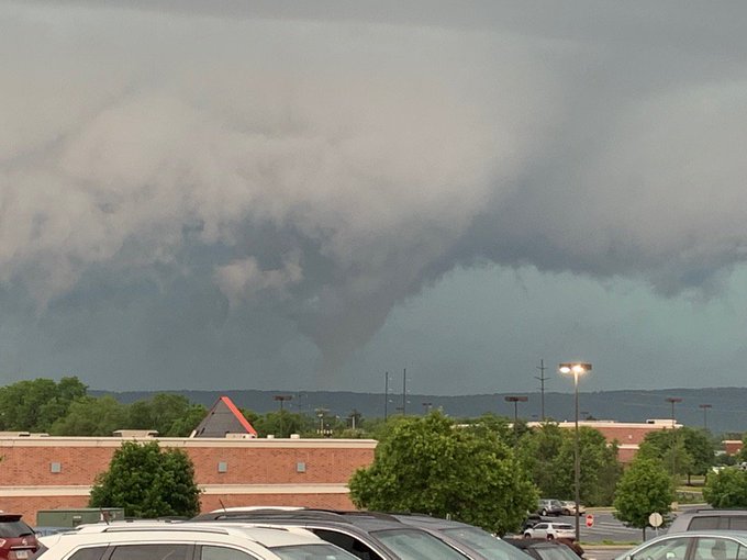
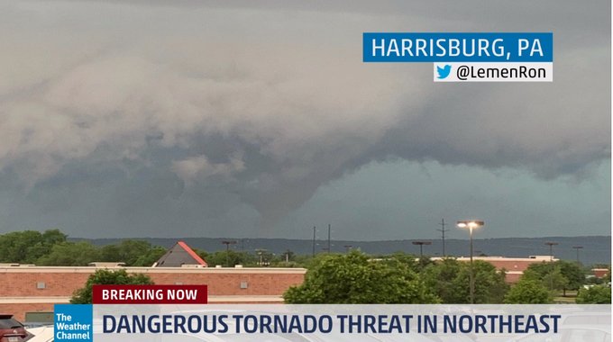
This tornado reportedly touched down near Harrisburg, Pennsylvania, earlier this evening as severe storms tracked across the region: t.co/HZ8IUWDzG3
You can follow NWS State College on Twitter here.
That is a great view of what looks to be a fairly big cone tornado in Harrisburg PA no less Credit – @LemenRon
The forecast and radar page for State College can be found here. On that page, the NWS indicated there was a tornado watch for the area until 8 p.m. on May 29. The page indicates:
“IN PENNSYLVANIA THIS WATCH INCLUDES 12 COUNTIES
IN CENTRAL PENNSYLVANIA
ADAMS BEDFORD CUMBERLAND
DAUPHIN FRANKLIN FULTON
LANCASTER LEBANON PERRY
SCHUYLKILL SOMERSET YORK
Storms rolling through Harrisburg #pawx

THIS INCLUDES THE CITIES OF BEDFORD, CARLISLE, CHAMBERSBURG,
GETTYSBURG, HARRISBURG, HERSHEY, LANCASTER, LEBANON,
MCCONNELLSBURG, NEWPORT, POTTSVILLE, SOMERSET, WAYNESBORO,
AND YORK.”
The forecast for the area was given as follows by NWS:
For May 29: “Showers and thunderstorms before midnight, then a slight chance of showers between midnight and 3am. Some storms could be severe, with large hail, damaging winds, and heavy rain. Low around 67. West wind 3 to 8 mph. Winds could gust as high as 21 mph. Chance of precipitation is 90%. New precipitation amounts between a quarter and half of an inch possible.
Thursday
Showers and thunderstorms, mainly after 3pm. Some storms could be severe, with large hail and damaging winds. High near 80. West wind 3 to 5 mph. Chance of precipitation is 80%. New rainfall amounts between a tenth and quarter of an inch, except higher amounts possible in thunderstorms.
Thursday Night
Showers and thunderstorms. Some storms could be severe, with large hail and damaging winds. Low around 64. Southwest wind 3 to 8 mph. Chance of precipitation is 80%. New precipitation amounts between a quarter and half of an inch possible.
Friday
A slight chance of showers before 9am. Mostly sunny, with a high near 78. Northwest wind around 7 mph. Chance of precipitation is 20%.
Friday Night
Partly cloudy, with a low around 60. Calm wind.
Saturday
A chance of showers and thunderstorms after 3pm. Mostly sunny, with a high near 81. Chance of precipitation is 40%.
Saturday Night
A chance of showers and thunderstorms. Mostly cloudy, with a low around 61. Chance of precipitation is 40%.
Sunday
A chance of showers, then showers likely and possibly a thunderstorm after 9am. Mostly cloudy, with a high near 73. Chance of precipitation is 60%.”