
It may be early in what has so far been a mild winter, but sporadic snowfall across Montana has pushed several river basins at below normal snowpack.
The heaviest early-season snowfall has been concentrated along the Continental Divide in western and southcentral Montana, where snowpack is closest to normal levels.
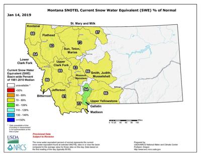
Of the three major river basins in the state, the Columbia, Missouri and Yellowstone all are registering in the mid to lower 80 percent of normal range for snow to water equivalent. At 94 percent, the highest smaller river basin is the Gallatin, while the Sun, Teton and Maris are the lowest at 73 percent.
And Montana's snowpack is far below last year's extremely snowy winter, at only about two-thirds of those levels.
Sites recording near normal snowfall levels likely would also have fallen below normal if not for a storm that dropped significant snow in late October and early November, said Lucas Zukiewicz, hydrologist for the USDA Natural Resources Conservation Service.
People are also reading…
“Many areas that were overlooked by the early November weather remain below normal for snowpack at this time, except for some regions of western Montana along the Idaho border, which received heavy snowfall during the latter half of December,” he said.
December also saw above average temperatures across the state, aside from a cold arctic air during the first week of the month. Monthly temperature departures were 3-7 degrees above average in northwest and northcentral Montana and 1-3 degrees above average in southwest and southcentral Montana.
“After a long and hard winter of shoveling and shivering last year, it’s been a mild winter so far this year,” Zukiewicz said. “While that’s nice in some ways, it’s the cold snowy weather during winter and spring that assures our water supply when it warms up in the summer.”
Fortunately, last winter’s heavy snowfall has aided reservoirs this year, with reservoir storage across the state above average in many basins due to abundant runoff last spring and summer. Zukiewicz said this could prove to be important should the weather take a turn to the dry and warm side through the rest of winter.
“Forecasts issued for the month of January aren’t painting a pretty picture of things to come and are calling for above average temperatures and below average precipitation,” he said.
Long-term weather forecasts by the National Weather Service predict that El Nino is expected to form and continue through the Northern Hemisphere through this winter and spring. Although basing snowfall forecasts off of one factor “isn’t always the best idea,” Zukiewicz noted that it will play some role in weather patterns over the next few months and should be monitored.
Montana is expected to see its next winter blast at the end of the week.
“Cold temperatures are expected to settle back in over much of the treasure state later this week,” according to the National Weather Service. “Increased chances for snowfall across much of the state will also accompany these cold temperatures from Thursday through Saturday.”
Snow will develop Thursday from the southwest to northeast across Montana. Periods of steady accumulating light snow is expected from Thursday afternoon through Friday morning before diminishing to snow showers by Friday afternoon.
The cold air mass will move out of the region late Saturday and Sunday, with gusty winds developing along the east slopes of the Rockies.
• In northcentral Montana, snow is likely late Thursday through early Friday with accumulations of 1-3 inches on the plains and 3-5 inches in the mountains. Steady temperatures in the 20s Thursday and Friday with overnight low temperatures in the single digits and teens are expected.
• In southwest Montana, snow is likely Thursday through early Friday with accumulations of up to 2 inches in the valleys and 3 -5 inches in the mountains, including the West Yellowstone area. Temperatures are expected to fall to the 20s Thursday and remain in the 20s Friday, with overnight low temperatures in the single digits and teens.
• Eastern Montana is expected to see the lowest snowfall but also the lowest temperatures, falling to single digits to below zero wind chills.
For the two week forecast, the weather service predicts a better chance for above average temperatures in central and western Montana, and a better chance for below average temperatures in eastern Montana.
Reporter Tom Kuglin can be reached at 447-4076 @IR_TomKuglin

Tom Kuglin
State Reporter/Outdoors Reporter