- India
- International
Saturday, May 04, 2024
Journalism of Courage
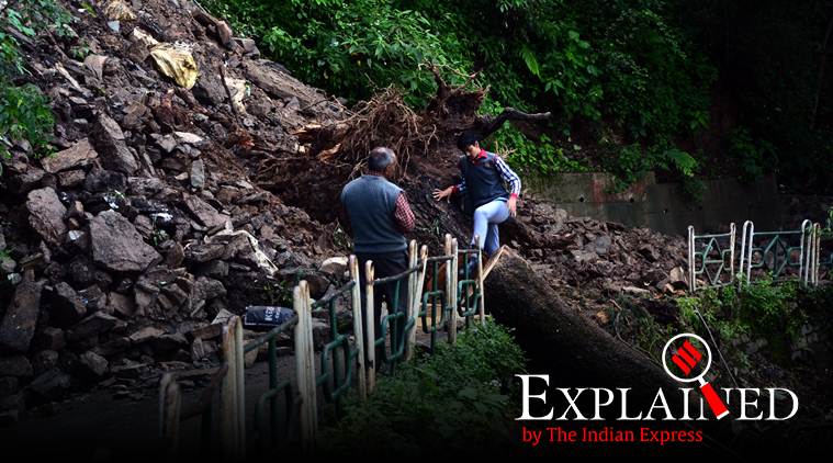 A road is blocked following a landslide due to heavy rainfall in Shimla, Tuesday. (Express Photo: Pradeep Kumar)
As Punjab grapples with floods, which Chief Minister Amarinder Singh termed as “unprecedented”, the blame is more on the rainfall in catchment area of Sutlej river in Himachal Pradesh, than on rain back home. Kanchan Vasdev explains why:
Which are the districts that witnessed the fury of floods in Punjab this time?
Several villages in six districts including Patiala, Sangrur, Moga, Ropar, Jalandhar and Ferozepur were inundated. Mostly the districts lining the Satluj river in Malwa and Doaba regions of the state were affected due to overflowing of river in some areas and breaches in the bandh on the river in others.
Is heavy rain alone to be blamed for floods?
Punjab experienced just 5 per cent more rain than last year as of August 20. Last year the state had witnessed 343.2 cm rainfall while this year it has been 357.3 cm. The districts that experienced heavy rainfall — between 15 to 20 cm — this year include Gurdaspur, Nawanshahar, Hoshiarpur, Jalandhar, Pathankot, Ludhiana, Patiala and Fatehgarh Sahib. Rest of the districts experienced a moderate rainfall ranging between 4-8 cms. Irrigation department says more than the rain in the state, it is the rainfall in the catchment area of Satluj river in Himachal Pradesh that was responsible for the floods.
How did the rain in Himachal Pradesh cause floods in Punjab?

Bhakra dam, built on Satluj, is filled to the brim a month before the reservoir’s filling season comes to an end. The dam’s filling season lasts till September 22. But it crossed its permissible storage level of 1,680 feet on August 19 and reached 1,682 feet despite the Bhakra Beas Management Board (BBMB) opening the spillways by upto eight feet and releasing water in the Satluj river. The swelling of Satluj due to opening of spillways caused floods. The inflow in the reservoir was recorded at 1.30 lakh cusecs (cubic metres per second) on August 19. The rain stopped in the catchment area on August 19 and the inflow has come down to 50,000 cusecs while the outflow through turbines and floodgates collectively amounted to a release of 76,000 cusecs.
What is the carrying capacity of Satluj river?
Satluj can safely handle 2.5 lakh cusecs but can carry up to 4 lakh cusecs of water. Irrigation experts say that opening of floodgates, coupled with silting of river, and poor maintenance of bandhs caused the breaches and overflowing of the river thereby leaving several parts inundated. The heavy silting in the river was caused by the state not issuing contracts for mining in the entire last fiscal year. Experts say the sand kept accumulating but it could not be mined thereby reducing the carrying capacity of the river. Also, the enchroachments in the natural drains and channels are to be blamed for poor drainage.
Is the threat over?
The IMD has forecast another spell of rain in catchment area on August 24, 25 and 26. With water level in Bhakra dam already at its highest point of permissible level and inflow still continuing, the threat is still there. The BBMB, in a meeting with three states including Punjab, Haryana and Rajasthan on Tuesday, decided to keep the level at 1680 feet by continuously releasing water through floodgates. The BBMB had on its own reduced the permissible limit at 1680 feet, bringing it down by five feet from 1685 feet in 1988 when Punjab had experienced worst floods.

It is imperative we teach our kids how to behaveSubscriber Only
How DDA built the middle class dream and shaped modernSubscriber Only

16th edition of the Habitat Film Festival to begin inSubscriber Only

India's dark chocolate market is growing. Who is taking theSubscriber Only

The complex journey of transgender rights in ChristianitySubscriber Only

Heeramandi, Sanjay Leela Bhansali's much anticipated web-series, recently dropped on Netflix, featuring a star-studded cast including Shekhar Suman, Adhyayan Suman, Manisha Koirala, Richa Chaddha, and Fardeen Khan. Adhyayan, who plays Zoravar Ali Khan, spoke about his struggles in the industry and how his parents' support helped him cope.