- India
- International
Tuesday, Apr 16, 2024
Journalism of Courage
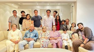
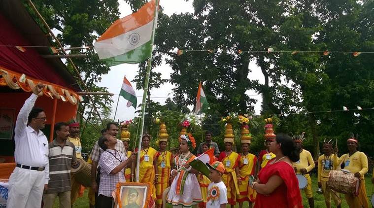 Independence Day celebrations on August 18, 2017 in Shibnibash, Nadia district, West Bengal. (Photo credit: Anjan Sukul)
As the whole of India celebrates Independence Day on August 15 every year, for some villages in West Bengal it is their time for an annual wait: they celebrate their day of independence a few days later, when they officially became a part of India in 1947.
On August 12, 1947, Viceroy Louis Mountbatten announced that the country would be given its freedom on August 15, 1947. Bengal, however, remained a contentious subject because according to the recommendations of Cyril Radcliffe, the British official in charge of drawing up the demarcations for maps for the partition of India, several districts like Malda and Nadia with large Hindu populations were given to East Pakistan, now Bangladesh.
According to some residents of villages near the Indo-Bangladesh border interviewed by indianexpress.com, Mountbatten’s announcement was followed by widespread protests in the region and August 15, for them, was not a cause for celebration of independence. The villagers say that according to stories passed down in their families, political leaders like Syama Prasad Mukherjee and members of the Nadia royal family took their protests to the British administration in Kolkata and the matter was brought to the attention of Mountbatten. In the following days, Mountbatten hastily ordered a redrawing of the partition of Bengal to include the protesting Hindu-majority districts into Indian territory and gave Muslim-majority districts to East Pakistan, a process that was concluded on the night of August 17.
This lesser-known part of Indian history continues to be commemorated in some villages near the Indo-Bangladesh border in West Bengal even to this day. Instead of August 15, every year these villages mark August 18 as their day of independence, not only from the British but also from East Pakistan, and recognise it as the day they officially joined India.
At Shibnibash, a small village in the Nadia district, approximately five hours away from Kolkata, 49-year-old Anjan Sukul has been organising Independence Day celebrations on August 18 since 1991. “My grandfather was a freedom fighter and I heard the story from him, but there are no written records of this,” says Sukul in an interview with indianexpress.com.

According to Sukul, the story of how the village came to commemorate its independence on August 18 was common knowledge passed down over generations, but nothing had been done to mark the day till Sukul took the initiative. “Prior to this we didn’t have the courage to fly the flag after August 15,” says Sukul, explaining the hesitation felt by the villagers in doing something that would be considered unusual by other people.
Eleven years ago, in the town of Bongaon in North 24 Parganas district in West Bengal, the Bongaon Bar Association decided to mark the day they became a part of India by hoisting a flag on August 18 on the Bongaon court premises. “The Bongaon subdivision got independence on August 18, 1947 and at 10:30 am we became a part of India. We didn’t get independence on August 15,” says Samir Das, Bongaon public prosecutor in-charge and secretary of the Bongaon Bar Association.
According to Das, there are some records of this date in the Bongaon sub-divisional office and residents had been aware of the town’s history. “Many weren’t sure of how this would be perceived, so we didn’t (celebrate) it before,” says Das. The first location where Bongaon residents hoisted the national flag of India was the local Treasury Office after which the location was moved to the local courthouse. “East Pakistan flags were flown on the days after August 15, 1947 till they were taken down and replaced by the Tricolour that was hoisted on August 18,” says Das.
Other than Shibnibash, in the Nadia district, the towns of Shantipur, Kalyani, Bongaon, Ranaghat, Krishnagar, Shikarpur and Karimpur were all part of East Pakistan and also celebrate Independence Day after August 15. “Ranaghat became a part of India on the night of August 17 and so they celebrate it on that day,” says Sukul.
The village of Ratua in the district of Malda and the village of Balurghat in Dakshin Dinajpur district are two other towns that celebrate independence day after August 15. The varying dates on which these villages celebrate Independence Day is due to the fact that not all villages were included as part of India on the same day. Hence, the villages mark their day of independence on the date on which they were officially removed from East Pakistan. “We also hoist the flag on August 15, but we officially celebrate Independence Day on August 18,” says Sukul.
The Partition of Bengal which was first announced in 1905 by Viceroy George Curzon, to split provinces along religious lines between Hindus and Muslims, led to the official start of the Swadeshi movement against the British on a pan-India scale. The widespread protests against this decision went on for six years and ultimately forced the British to reverse their plans for the Partition. In 1911, the reigning King George V announced the reversal and ordered the assimilation of affected provinces into the Bengal Presidency.
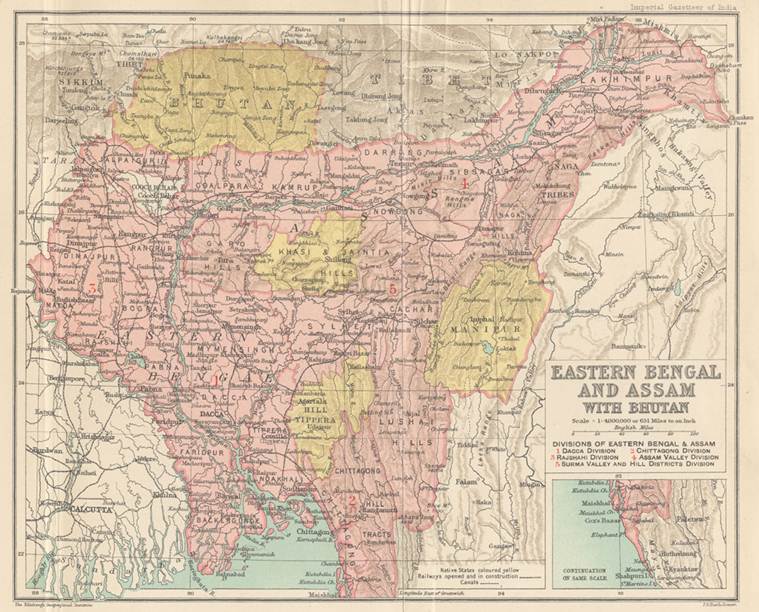 Source: The Imperial Gazetteer of India. Volume 11. 1908.
The chaos over this decision was the trigger for the start of separatist Muslim politics, with the British having succeeded in creating the framework for the division of the nation on religious lines. In 1947, Bengal was subjected to partition once again on the basis of religion that led to the formation of the independent nations of India, Pakistan and East Pakistan, that later became Bangladesh in 1971.
Prior to the appointment of Louis Mountbatten in February 1947, Archibald Wavell served as Viceroy of India and during his tenure drew up a crude map of borders dividing the nation. Soon after Mountbatten arrived in India, he appointed Cyril Radcliffe to chair two Boundary Commissions for Punjab and Bengal, to divide the nation along religious lines between Muslims and Hindus.
Radcliffe, a lawyer by profession, who had never been to India and was neither familiar with its geography, diversity and complexity, arrived in India for the first time in July 1947. He was tasked with the division of this land that had more geo-political, socio-cultural, socio-economic and socio-religious consequences than he could have imagined and it was an undertaking that he adjudicated upon with no prior experience. Mountbatten, who was impatient to return to England and had accepted the appointment of Viceroy on the conditions of a fast division of India, put pressure upon Radcliffe to conclude the matter at an accelerated pace. The British did not engage in any land surveys or inspection for information that a procedure of territorial division of this kind would require and deliberately kept the United Nations out of partition mediations to maintain control and to finish the process at the speed that Mountbatten wanted.
In an interview with veteran journalist Kuldip Nayar in the 1960s, Cyril Radcliffe gave his side of the story of the Partition of India and blamed the “quality of district maps” available to him for the violence and chaos that had followed. “I was so rushed that I had not time to go into the details. Even accurate district maps were not there and what material there was also inadequate. What could I do in one and a half months?” said Radcliffe, as quoted in Nayar’s book ‘Distant Neighbours: A Tale of the Subcontinent ‘.
However, Willem van Schendel, a professor at the University of Amsterdam, who has researched the subject of the history of Bengal’s borders extensively, disagreed with Radcliffe’s justifications. In his book ‘The Bengal Borderland: Beyond State and Nation in South Asia’, Schendel writes that “although there were…errors in the district maps, what is much more striking is how accurate they turned out to be over most of the length of the border. From Radcliffe’s comment it is also clear that the Boundary Commission restricted itself to the use of district maps and ignored the much more detailed mouza (revenue village) maps on which these were based.”
In many ways, the Partition of India is actually the story of the Partition of Punjab and the Partition of Bengal.
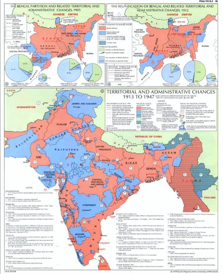 Map credit: Historical Atlas of South Asia by Joseph E.Schwartzberg
The Bengal Commission was made up of five people including Radcliffe, where he made all final decisions. Two members of the Indian National Congress and two members of the Muslim League formed the rest of the commission. According to the border divisions Radcliffe made with regard to Bengal, the Muslim majority district of Murshidabad was given to India in order to ensure that Calcutta received water from the Ganges river. Khulna, a district in Bengal with a large Hindu population was included in East Pakistan, now Bangladesh.
In her book ‘The Spoils of Partition: Bengal and India, 1947-1967 ‘, Joya Chatterji, professor of history at Trinity College, writes that one of the ironies of the Partition of India was in how similar Radicliffe’s borderlines were with those drawn by Curzon in his plans for the Partition of Bengal in 1905.
The story of party symbols in Indian electionsSubscriber Only
Explained: A short history of Iran-Israel ties and why theySubscriber Only
10 years on, BJP manifesto signals continuity amid changeSubscriber Only
AAP Bharuch candidate's frontline fighters are his two wivesSubscriber Only

K-beauty boom: Do Korean creams really work on Indian skin?Subscriber Only
Idea Exchange with Political scientist John J MearsheimerSubscriber Only
No real buzz for BJP in western UP, but OppositionSubscriber Only
Why the swanky Surat Diamond Bourse is struggling to attractSubscriber Only