DENVER — Warmer weather has moved into Colorado and is here to stay for the next few days. The rest of Wednesday evening will stay dry with clear skies across the state.
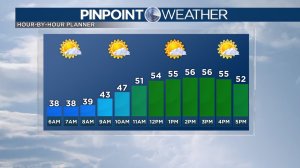
Thursday will be similar to Wednesday. In Denver, high temperatures will reach the mid to upper 50s in the afternoon with sunny skies and dry conditions.
Friday will stay in the upper 50s with more dry and sunny weather. Winds will pick up late on Friday as a cold front approaches from the north.
Snowfall will start Saturday morning on the northern Front Range and northeast Plains and will shift south through the day. As of now, the northern Front Range and northeastern mountains will most likely see the highest accumulation from this storm. Totals will be lower as you reach metro Denver and points southward. Totals will most likely be below 2 inches for most of Denver.
The Pinpoint Weather Team will have more details on this storm as it gets closer.
Colorado will dry out on Sunday morning with high temperatures in the 40s.
Highs climb back into the 50s to start next week with a dry weather pattern.
Check interactive radar and zoom in to where you are. Plus, check the radar anytime with the Pinpoint Weather App for iPhone and Android.

Pinpoint Weather has been independently certified as Colorado’s Most Accurate Forecast by WeatheRate.
We’re tracking weather today on FOX31 Denver and Channel 2 News – and when conditions are bad we send out the Weather Beast.


