By VERNON ROBISON
Moapa Valley Progress
The Clark County Department of Aviation has long seen a need to extend the perimeter around Perkins Field Airport in Overton for added security. And the time to address that need has nearly come.
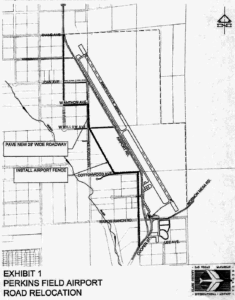
Plans have been drawn to change the route of the old Airport Road which has historically run only about 60 feet from the airport taxi-way. The airport fence would also be moved further west to the edge of the airport property to allow a buffer between the roadway and the airport runway and taxi-way.
According to plans presented for information only to the Moapa Valley Town Advisory Board in a meeting last month, the old Airport Road would be replaced by a zig-zag route across the open desert property just west of the airport. Altogether, the new route would add up to about 1.4 miles of newly paved 29-foot-wide roadway. The project is estimated to cost about $5.5 million.
Construction is expected to begin sometime in the latter half of 2020. County officials say it could take 9 to 12 months to complete.
The preliminary map shown to the town board indicates that the existing Cooper Street approach to Airport Road would veer slightly west roughly at Lee Ave, just north of the Cooper Street Bridge. From there it would continue straight north running parallel to the existing Airport Road about 100 feet west of the current route.
At the Cottonwood Ave. alignment, the road would proceed west for approximately 450 feet of new pavement.
Then it would jog in a diagonal route to the northwest, across what is currently empty desert land, to the intersection of Willow Ave. and Anderson Rd.
From there, the route would proceed directly north, only about 300 feet along a newly paved section of Anderson Street. At that point, the route would turn west at Anthon Ave. for 650 feet to the Lou Road alignment.
Finally, the route would span another 1500 feet due north to connect with the existing pavement at N. Lou Street near the end of the airport runway.
Click HERE to see a larger version of the map.