Weather
Tornado Watch Issued For Parts Of MD, Flash Flood Watch Extended
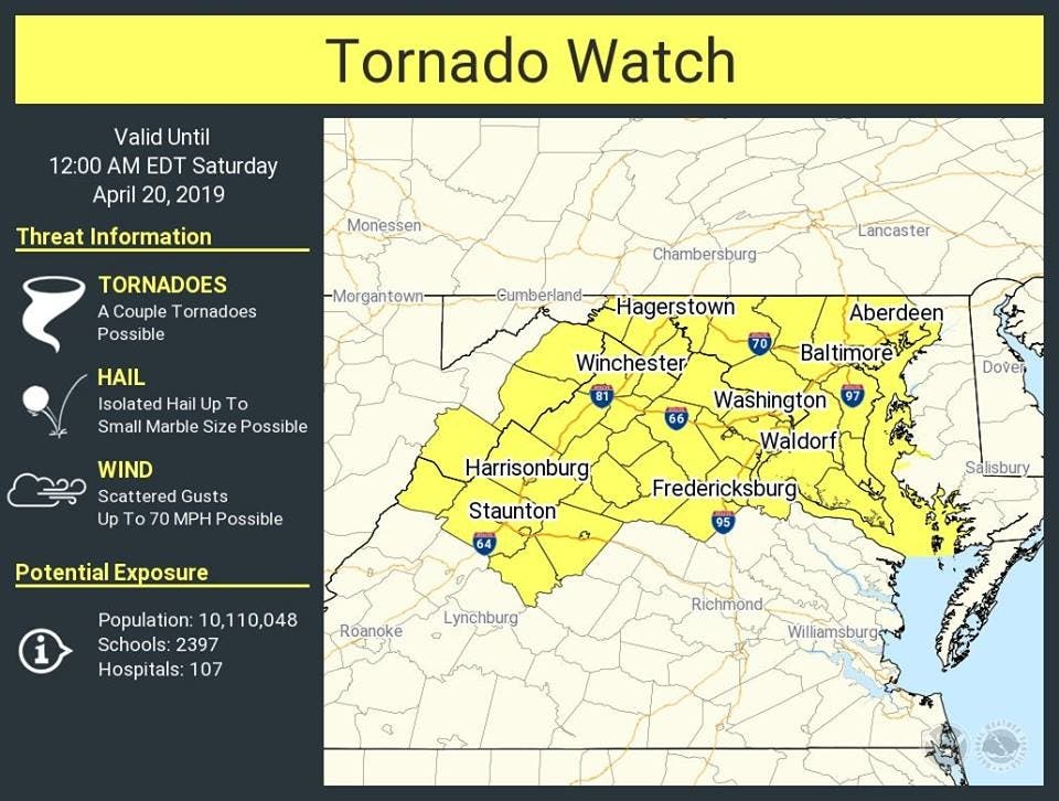
Much of Maryland is under tornado watch Friday, while more counties have been added to a flash flood watch into early Saturday.


BALTIMORE, MD — Maryland's Easter weekend weather forecast has gone from soggy to dangerous with a tornado watch in effect until midnight on Friday. And a flash flood watch issued by the National Weather Service has expanded to more counties; it went into Friday afternoon and run until 5 a.m. Saturday with thunderstorms capable of dumping 3 inches of rain in parts of the state.
"Showers and thunderstorms will increase in coverage across the area this afternoon, and again this evening," forecasters with the National Weather Service wrote. "Damaging winds, tornadoes, and flooding rain will be possible. Stay weather aware this afternoon and evening!"
Counties under the tornado watch are: Anne Arundel, Howard, Montgomery, Prince George's, Carroll, Frederick, Washington, Baltimore, Harford, Calvert, Charles and St. Marys, along with the city of Baltimore.
Find out what's happening in Annapoliswith free, real-time updates from Patch.
Cities in the tornado watch include: Aberdeen, Annapolis, Arnold, Baltimore, Bel Air, Bethesda, Bowie, California, Camp Springs, Catonsville, Chesapeake Beach, Clinton, College Park, Columbia, Dundalk, Eldersburg, Ellicott City, Essex, Frederick, Gaithersburg, Germantown, Glen Burnie, Greenbelt, Hagerstown, Havre De Grace, Joppatowne, Laurel, Odenton, Parkville, Potomac, Rockville, Severn, Severna Park, Silver Spring, South Gate, Suitland-Silver Hill, Towson, Waldorf, and Westminster.
"Repetitive storms and multiple rounds of heavy rain may result in rainfall amounts which could exceed 3 inches locally. Flash flooding is possible, particularly in urban areas and in areas of steep terrain," the Weather Service warns.
Find out what's happening in Annapoliswith free, real-time updates from Patch.
These parts of Maryland are under the flash flood watch from noon Friday, April 18, to 5 a.m. on Saturday, April 20: Anne Arundel, Calvert, Carroll, Howard, Montgomery, Charles, Frederick, Baltimore, Harford, Prince George's, St. Marys and Washington counties.
Cities in the flash flood watch area include: Baltimore, Bowie, Suitland-Silver Hill, Clinton, College Park, Greenbelt, Laurel, Camp Springs, Glen Burnie, Annapolis, Severn, South Gate, Severna Park, Arnold, Odenton, St. Charles, Waldorf, Germantown, Damascus, Bethesda, Rockville, Gaithersburg, Silver Spring, Lisbon, Columbia, Ellicott City, Jarrettsville, and Aberdeen.
Washington, D.C., and much of northern Virginia is also under the watch.
"Thunderstorms with heavy rain may cause flooding. Severe weather is also a threat," the National Weather Service posted.
Here's the detailed forecast from the National Weather Service:
Friday Afternoon: Showers and thunderstorms, mainly after 2pm. Some storms could be severe, with damaging winds and heavy rain. High near 76. South wind 13 to 16 mph, with gusts as high as 31 mph. Chance of precipitation is 80%. New rainfall amounts between a tenth and quarter of an inch, except higher amounts possible in thunderstorms.
Friday Night: Showers and thunderstorms before 2am, then showers likely and possibly a thunderstorm between 2am and 5am, then a chance of showers and thunderstorms after 5am. Some storms could be severe, with damaging winds and heavy rain. Low around 62. Southeast wind around 15 mph, with gusts as high as 29 mph. Chance of precipitation is 100%. New rainfall amounts between a half and three quarters of an inch possible.
Saturday: A chance of showers, mainly before 8am. Mostly cloudy, with a high near 72. South wind 13 to 17 mph, with gusts as high as 32 mph. Chance of precipitation is 30%.
Saturday Night: A chance of showers after 2am. Mostly cloudy, with a low around 52. South wind 5 to 10 mph becoming light after midnight. Winds could gust as high as 20 mph. Chance of precipitation is 30%.
Sunday: A chance of showers. Mostly cloudy, with a high near 65. Southwest wind 5 to 7 mph. Chance of precipitation is 50%.
Sunday Night: A chance of showers. Mostly cloudy, with a low around 51. Chance of precipitation is 30%.
Monday: Partly sunny, with a high near 71.
Monday Night: Partly cloudy, with a low around 56.
Get more local news delivered straight to your inbox. Sign up for free Patch newsletters and alerts.


