Weather
RI Weather: Timeline For Two Rounds Of Storms, Showers Today
Large hail, damaging winds and a shot at a "short-lived" tornado. Here's what to expect from today's storms.

There will be two rounds of rain coming through Rhode Island Wednesday, the latter of which will feature strong thunderstorms. A hazardous weather outlook is in effect for the state as forecasters warn of the potential for large hail and torrential downpours. There is also the low chance of a "short-lived tornado," the National Weather Service said.
The worst of the storms is expected between 3-10 p.m. Major wind gusts could knock down tree limbs and power lines, meaning outages could be a threat.
The first round of rain will see some hit-or-miss showers. What won't miss is the second round, which is coming late this afternoon and early this evening, depending on where you live. The storms are coming in from the west.
Find out what's happening in Newportwith free, real-time updates from Patch.
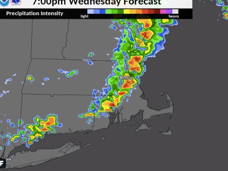
[Radar simulation] Here is an approximate timeline of showers/t-storms Wed afternoon/evening. Timing and location not meant to be exact. pic.twitter.com/uwvbaZLMKG
— NWS Boston (@NWSBoston) August 20, 2019
That doesn't mean it's going to be cool today. Max temperatures are still expected to be in the low-to-mid 80s.
More storms are expected Thursday.
Find out what's happening in Newportwith free, real-time updates from Patch.
Providence-area forecast via NWS
Tonight - A chance of showers and thunderstorms, mainly before 5am. Some storms could be severe, with gusty winds and heavy rain. Mostly cloudy, with a low around 73. Southwest wind around 9 mph. Chance of precipitation is 50%. New rainfall amounts between a quarter and half of an inch possible.
Thursday - A chance of showers and thunderstorms, mainly after 5pm. Patchy fog between 7am and 8am. Otherwise, partly sunny, with a high near 90. West wind 6 to 9 mph. Chance of precipitation is 30%. New rainfall amounts of less than a tenth of an inch, except higher amounts possible in thunderstorms.
Thursday Night - A chance of showers and thunderstorms, mainly after midnight. Mostly cloudy, with a low around 65. West wind 5 to 7 mph becoming northwest after midnight. Chance of precipitation is 30%. New rainfall amounts of less than a tenth of an inch, except higher amounts possible in thunderstorms.
Friday - A slight chance of showers and thunderstorms before 10am, then a slight chance of showers between 10am and 11am. Mostly sunny, with a high near 80. West wind around 7 mph. Chance of precipitation is 20%.
Friday Night - Mostly clear, with a low around 60. North wind around 7 mph.
Saturday - Sunny, with a high near 78. North wind around 7 mph.
Saturday Night - Partly cloudy, with a low around 59. Northeast wind around 6 mph.
Sunday - Mostly sunny, with a high near 73. Northeast wind 8 to 11 mph.
Sunday Night - Partly cloudy, with a low around 59. Northeast wind 6 to 9 mph.
Monday - Mostly sunny, with a high near 73. Northeast wind 8 to 11 mph.
Monday Night - Patchy fog. Otherwise, partly cloudy, with a low around 61. Northeast wind 7 to 9 mph.
Tuesday - Patchy fog. Otherwise, partly sunny, with a high near 75. Southeast wind around 9 mph.
Get more local news delivered straight to your inbox. Sign up for free Patch newsletters and alerts.