Weather
Austin Area Under Flash Flood Watch All Day Wednesday
As if we hadn't had enough strong storms this month, Wednesday calls for potentially severe storms with possible hail and flash flooding.


AUSTIN, TX — Heavy rain forecast for the Austin region on Wednesday has prompted the National Weather Service to issue a flash flood watch through early Thursday.
The advisory is set to be in effect from 7 a.m. on Wednesday, April 24, through midnight on Thursday as forecasters expect up to 6 inches to be dumped in isolated areas. The flash flood watch covers multiple counties, including Travis, Williamson, Blanco, Burnet, Gillespie, Hays and Llano.
A flash flood watch is issued by the National Weather Service when conditions are favorable for flash flooding in flood-prone areas, usually when grounds are already saturated from recent rains, or when upcoming rains will have the potential to cause a flash flood. With previous heavy rains in the past couple of weekend in particular, regional soil already is saturate, yielding conditions ripe for flash flooding.
Find out what's happening in Austinwith free, real-time updates from Patch.
The National Weather Service previously forecast a 40 percent chance of showers and thunderstorms was forecast for Tuesday afternoon. The day was mostly cloudy, and the high temperature reached around 78 degrees. The chance of showers was forecast mainly after 1 a.m., forecasters said, and the low temp dipped to around 66 degrees. Chance of precipitation fell to 60 percent by nightfall.
It's Wednesday when things get dicey, and residents might want to plan for inclement weather ahead of time. Some of the thunderstorms being predicted could be severe and produce heavy rainfall, forecasters said. The high temperature on Wednesday afternoon is expected to reach 75 degrees, with southeast winds between 10 to 15 miles per hour.
Find out what's happening in Austinwith free, real-time updates from Patch.
And regardless of where you are in the region, you will see rain as the chance of precipitation is 100 percent on Wednesday.
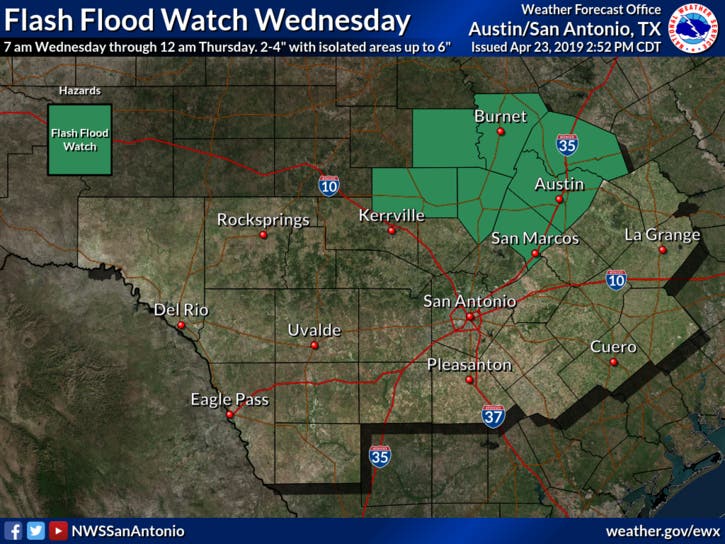
Image via National Weather Service.
By Wednesday night, more showers and thunderstorms are expected, mainly before 1 a.m. Some of these storms could be severe and produce heavy rainfall. The low is expected to drop to 60 degrees, and the wind will be light from the east-southeast at 5 to 10 miles per hour. Chance of precipitation: 90 percent.
Ahead of the storm, residents are urged to ensure they can fit their cars into their garages or carports to protect their vehicles from hail. As always, consult ATXfloods.comto check which low-water crossings are closed once the rain begins in earnest. To check on road conditions, visit DriveTexas.org.
The rain is expected to dissipate by Thursday, when there will be a slight chance of showers. The chance of precipitation drops to 20 percent, under mostly sunny skies and a high near 77 degrees. The NWS forecasters say Thursday night will be mostly clear, with a low around 60 degrees.
Sunny days continue through the weekend: Friday calls for sunny skies with a high near 81; Saturday will be the same but with a high near 85; and Sunday also will be sunny, with a high near 86 degrees.
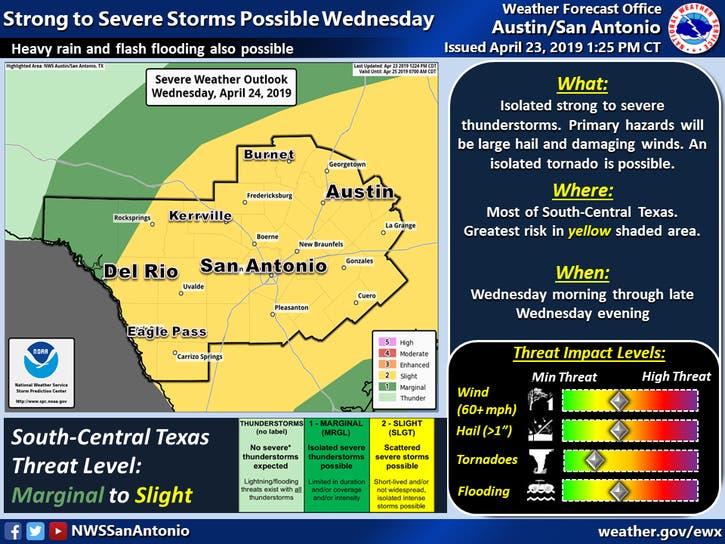
Image via National Weather Service.
Get more local news delivered straight to your inbox. Sign up for free Patch newsletters and alerts.
