At a Glance
- Dangerous fire weather conditions will grip parts of California into Monday.
- Wildfires could spread rapidly due to dry conditions and strong winds.
- The high winds could also bring down trees and power lines.
- Another round of high wildfire danger is expected midweek.
Strong winds and low humidity will continue to fuel an extreme wildfire danger in California into Monday, and wildfire conditions could once again worsen in parts of the state by midweek.
Southern California is facing a threat of extreme wildfire conditions as Santa Ana winds make a return on Monday.
(LATEST NEWS: More Evacuations Issued of Extreme Fire Threat)
Forecast
Northern California
Winds have gusted in excess of 90 mph on Sunday morning in the higher elevations of the North Bay region. A gust to 93 mph was clocked at Healdsburg Hills (elevation 2,480 feet). To the east, a wind gust of 107 mph was clocked near Alpine Meadows in the Sierra, Sunday morning.
The winds have caused the Kincade Fire to undergo a notable increase in activity through Sunday with a growth to over 84 square miles in size.
A new pair of fires also erupted near Vallejo and Crockett, near the San Francisco Bay Area, endangering the Carquinez Bridge and Interstate 80. Several other small fires also ignited north and south of the Bay Area.
Red flag warnings have been issued for parts of the San Francisco Bay Area and much of Northern California through Monday morning. This means that conditions will be favorable for rapid fire growth due to gusty winds and low humidity.
NOAA's Storm Prediction Center is forecasting extremely critical fire weather conditions in the northern Bay Area, including Fairfield and Napa, through early Monday. This is the highest fire weather category issued by NOAA.
Winds will remain gusty into early Monday, possibly strong enough to down trees, but certainly strong enough to spread wildfires including the Kincade Fire.
Southern California
Santa Ana winds will redevelop in Southern California on Monday.
As a result, critical to extremely critical fire weather conditions are forecast in parts of Southern California, according to NOAA's Storm Prediction Center. This is the highest fire weather category issued by NOAA.
Red flag warnings for the fire danger have also been issued for Southern California, including the Los Angeles area.

A potentially stronger Santa Ana wind event could create an even higher wildfire danger in Southern California Tuesday night through Thursday. Northern California might also see another round of gusty offshore winds, but they won't be as strong as the ongoing wind event Sunday into Monday.
The End of the Dry Season
Unlike most locations in the Lower 48 states, California has pronounced wet and dry seasons. The last weeks of the dry season happen in fall.
"California's Mediterranean climate makes it unique, as our warmest months coincide with our driest," said Jan Null, certified consulting meteorologist and adjunct professor in the Department of Meteorology and Climate Science at San Jose State University.
Both Los Angeles and San Francisco typically pick up only 9% of their average annual precipitation in the six-month "dry season" from May through October.
This amounts to a six-month average rain total of only 1.3 inches in L.A. and 2.25 inches in San Francisco.

It is a similar story in Sacramento, which gets about 11% of its average annual precipitation from May through October.
"By the end of the summer and into early fall, the state's vegetation has dried out," Null said.
This is true even after a wetter-than-average winter. Winter precipitation can cause an increase in grasses and other fuels, which add to the dry vegetation available to feed wildfires by fall.

High Winds Return to Fan the Flames
Summer's wildfires in California tend to burn more slowly and start in more remote areas, often due to lightning.
In the fall, California's offshore winds typically kick into gear, according to a 2017 climatology study.
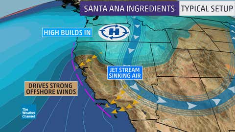
"In September and October, we begin seeing high pressure developing over the Great Basin, and this creates dry, warm offshore winds," said Null. "The air is compressed as it descends to sea level, warming and drying it. When this flow is forced over mountains and through canyons, it accelerates."
If the jet stream is also located to the east of the state over the Great Basin, a downward push of strong winds can occur, intensifying the offshore wind event. These intense offshore winds can occur from fall through spring.
What makes them particularly dangerous in the fall: they occur when soil moisture is at its lowest.
These Santa Ana or Diablo winds can quickly whip either an existing wildfire or a just-developed small brush fire into an inferno, blowing embers downstream, starting many more spot fires, sometimes in more heavily populated areas.
The fires can also persist for several days if the jet stream pattern persists, bringing high pressure to western North America, as occurred in both early December 2017 and early November 2018.
The Weather Company’s primary journalistic mission is to report on breaking weather news, the environment and the importance of science to our lives. This story does not necessarily represent the position of our parent company, IBM.