Dust off your scarves and wooly hats, Brummies, because Birmingham is braced for temperatures as low as -1C before the weekend.
The city will be gripped by plummeting temperatures as the mercury dips well below freezing, reaching -1C on Friday and nudging below the freezing mark tomorrow (Thursday), too.
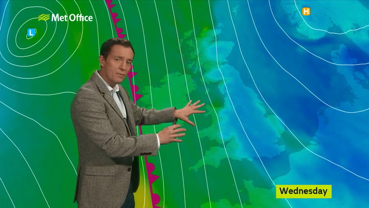
City residents are told to expect a fine day for most on Wednesday, with variable amounts of cloud and some brighter or sunny spells, but there is a noticeable chill in the air.
A few spots of rain cannot be ruled out at first, but it should remain dry for most before temperatures plunge to freezing overnight, according to the Met Office.
The agency has also warned over "hill snow" in parts of the Midlands region.

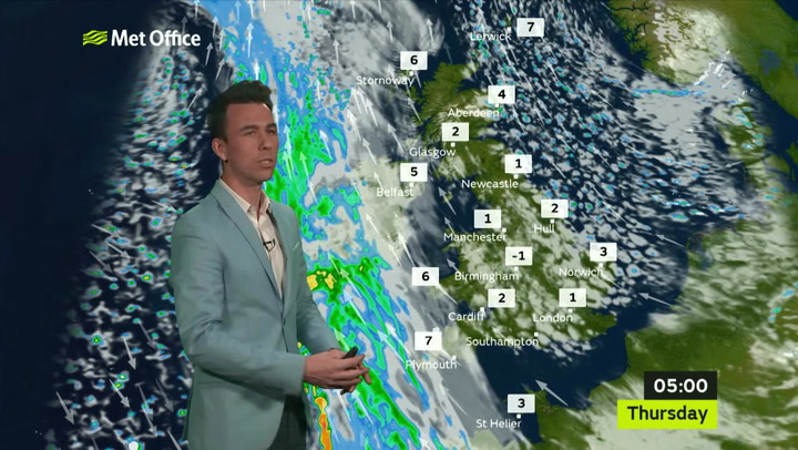
Thursday sees a "chilly start, with brisk winds" before early cloud disperses, with some prolonged spells of sunshine likely by the afternoon and staying dry.
It will remain cold throughout with overnight frost lingering, with winds then "strengthening Saturday, as rain and hill snow spreads east."
Meteorologist Aidan McGivern told the Express: “Because of the clearest skies and the lightest breeze will be in the east.
“Here, temperatures will drop to -1 or -2 degrees before coming up a little bit by dawn.
“So a chilly start for eastern parts of England, eastern Scotland, some sheltered spots of central Britain but plenty of sunshine in the colder spots and that sunshine becomes more widespread through the day.”
Weather October 2018


Ten inches of snow will wreak havoc across the wider country, with the Grampians in Scotland hit worse, but also the North York Moors suffering from a heavy amount of the white stuff.
Watch: How cold does your office need to be before you can go home?
More persistent rain will spread into western Scotland through Friday afternoon before turning to snow over 200m and a mix of rain and snow down to lower levels - accumulations are expected to be limited to higher ground with 5-7cms but locally 10-15cms over the highest levels.
Rain will spread east overnight into Saturday becoming widespread with some heavy falls over the west and turning to snow over higher ground with a mix of rain and snow down to lower levels northwards from the Midlands.
This will soon turn to rain with winds fresh to strong southeasterly with gusts possible 40-50mph over the south and west coasts.
A spokesperson for The Weather Channel said it would eventually start to turn milder during the weekend when low pressure allows less-cold air to be pulled towards the UK from the south-west.
Five-day Birmingham weather forecast
A fine day for most, with variable amounts of cloud and some brighter or sunny spells. A few spots of rain cannot be ruled out at first, but it should remain dry for most. Maximum temperature 8 °C.
Tonight:
Clear spells at first, and turning cold, with a risk of frost. Likely turning cloudier by dawn, with the risk of some hill fog across the Peak District. Minimum temperature 0 °C.
Thursday:
A chilly start, with brisk winds. Early cloud will disperse, with some prolonged spells of sunshine likely by the afternoon and staying dry. However it will remain cold throughout. Maximum temperature 5 °C.
Outlook for Friday to Sunday:
Cold, largely sunny Friday, with overnight frost. Winds then strengthening Saturday, as rain and hill snow spreads east. Turning less cold Sunday with sunny spells, and blustery showers or rain.