Recently, my Civil Beat colleagues and I decided that the world needs to know just how nerve-wracking it can be merging east onto the H-1 Freeway at University Avenue, so we shot a minute-long video and posted it across social media:
To me, that crazy entrance has always been the poster child for all the haphazard designs that make navigating Honolulu’s roads so tricky.
Drivers embarking at University have maybe 15 yards to merge onto the freeway as cars fly past. Those who dare to enter there have to floor the gas pedal like they’re driving the getaway car in a bank robbery just to avoid a collision.
![]()
The video drew a lot of reader response, with local commuters flagging other problem spots across the island.
But merging onto the freeway, it turned out, wasn’t even the hardest place we navigated on our film shoot.
Instead, my co-pilot Carlie Procell and I quickly realized as we circled around lower Manoa that the intersection where King Street merges with Waialae Avenue, near the Hawaii Humane Society, requires even more skill and fortitude.
TRIGGER WARNING: The following screenshot, taken from Google Maps, might cause local drivers to feel helplessness and despair.
![]()
I don’t know if you can even call that configuration an “intersection.”
Just look at everything that’s going on in that frame. It seriously makes me nervous.
The spot is especially bad for the drivers who’ve just exited the H-1 Freeway and then head Ewa-bound on King toward University, per the yellow arrow above. To cross, they have to wait for a smorgasbord of cars moving in three different directions in front of them to clear. It’s one of the worst traffic gantlets to run in Honolulu, particularly during rush hour.
(The only way Carlie and I got through was thanks to the aloha of our fellow drivers. They eventually took pity and stopped to let us pass. Mahalos and shakas to you guys!)
King/Waialae is bad, but it’s hardly unique.
Honolulu is dotted with such labyrinthine intersections — spots where the streets tangle awkwardly together, sucking in drivers and spitting them out in a completely different direction if they’re not careful.
Many of these intersections are remnants of a bygone era. They took shape before the island was so saturated with cars and before the H-1 split Honolulu’s streets and neighborhoods in two, complicating the local traffic patterns.
Historical maps help tell the story of how our current fates were sealed, in some cases more than a century ago. Here’s another tricky spot — the intersection near Kawaiahao Plaza — depicted in a survey map back in 1911:

About 108 years later, a Civil Beat reader wrote to say she’s considering painting the lines in that intersection herself “in the dead of night” to make it easier to navigate.
Meanwhile, even as far back as 1881 maps show that King/Waialae merge starting to take shape:
![]()
Twenty years later the streets were developed a bit more. King still didn’t extend as far east as it does now, and roads such as Kapiolani and Harding Avenue didn’t yet exist, according to this 1902 map:
By 1950, all the surface streets that make up King/Waialae are there. The one big piece missing is the H-1 Freeway, which wouldn’t be completed for another decade or so.
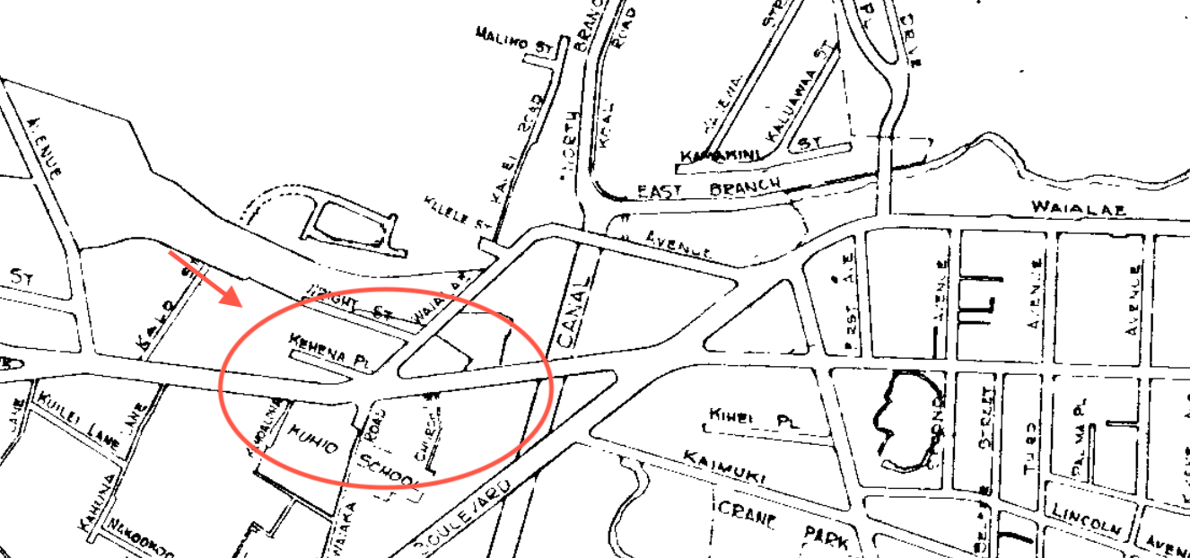
“Standards evolve over time,” said Jon Nouchi, the city’s deputy director for Transportation Services. “Things like freeways tend to carve up neighborhoods, and that’s how we end up getting some of our roadways.”
From roughly the 1950s to the 1990s, local traffic engineers largely focused on moving as many vehicles along the main roads as they could instead of prioritizing how to make those streets work best for surrounding homes and businesses, Nouchi said.
The decision about 40 years ago to convert King and Beretania into one-way streets is a prime example.
The trend toward maximum car flow was also “how I think we got to that monster 5-way intersection at Kapiolani and Date and Kamoku street,” Nouchi said.
Here’s that pentagonal monster:
![]()
Drivers on Kapiolani heading toward Kaimuki have to abruptly merge into two left lanes or they’ll be forced to turn onto Date Street. Drivers on Kamoku aren’t given the option to cross through the intersection and stay on that street.
Drivers on Kapiolani can’t turn left onto Date at all.
Everyone feels better when they’ve gotten past this spot.
Nouchi called the King/Waialae split and the nearby intersection at Market City “a perfect storm of messes.”
“It was just the way that these major roads came together, plus complicating it with a body of water” — the Palolo Stream — “that led to it being a really weird place,” he said.
It is possible to redesign such spots, Nouchi added. However, the city would need a strong reason to do so. Usually, there has to be a real safety concern that transcends the general nuisance and headaches of the design.
It’s also hugely expensive, said David Callies, a professor at the University of Hawaii, Manoa William Richardson School of Law who specializes in land use.
“Once you’ve got that density in place, it’s pretty hard to change,” he said.
Editor’s Note: Civil Beat reporter Marcel Honore’s transportation column, “Wayfinding,” offers a street-level look at the challenges of getting around Oahu and the neighbor islands. If you want to share your story ideas or experiences, send an email to mhonore@civilbeat.org.