
 "Kolhapur floods: Activist blames Maharashtra govt, claims areas along Panchganga river redefined as residential zone")
Pune: An activist from Pune has blamed the Maharashtra government for the recent deluge in Kolhapur, alleging that flood lines of the Panchganga river there were “redefined” to provide benefits to the construction sector.
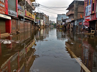
Hundreds of villages in Kolhapur and neighbouring Sangli were flooded after heavy rains earlier this month. While 55 people died in flood and rain-related incidents, lakhs were evacuated in these western Maharashtra districts.
Environmentalist Sarang Yadwadkar, who claimed to have accessed some documents of the irrigation department through RTI, said around 500 hectors land along the Panchganga river, which should have been in the flood-affected area (prohibited zone), was marked as residential zone in Kolhapur’s development plan (DP) by “redefining” the flood lines.
There are two types of flood lines, blue for the flood level that occurs once in 25 years and the red for that happens once in 100 years, he said. “The irrigation department issued a circular in 1989 to mark the flood lines for all rivers in Maharashtra, but it was ignored. Instead of the flood lines, flood levels (general level of a particular flood) were marked and these levels were later superimposed on the DP maps of Kolhapur,” he claimed.
In one of the cases in 2015, the National Green Tribunal (NGT) issued directives to the irrigation department to mark both the flood lines over rivers across the state, the activist claimed. “The irrigation department started the survey work in 2017 and by 2018 it identified the flood lines (considering water flow at 2.14 lakh cusec for blue line and 3.22 lakh cusec for red line) for the Panchganga river and submitted it to the Indian Institute of Technology Bombay,” he said.
He said the IIT Bombay also verified the report and stated that the flood lines were correct. But, when the Kolhapur chapter of the Confederation of Real Estate Developers Association of India (CREDAI) came to know about it, it found around 500 hectors land going below the blue line and by default becoming a ’no development’ zone, Yadwadkar said.
The CREDAI, Kolhapur, in October 2018 wrote a letter to the chief minister, stating that the work of demarcation of flood lines is done by a private agency, Yadwadkar said. “It also stated that the 1989 flood-level is marked on the DP and as the flood that year was the largest, it was pointless to mark new flood lines. It stated that new flood lines will create confusion and unrest among people,” he said.
He said the CREDAI also stated in its letter that colonies and apartments were developed on most of the portion falling under the new flood lines. “The chief minister, in his remarks on the same letter, addressing the irrigation department’s secretary, wrote, ’the flood line marked with DP should be maintained’,” Yadwadkar said.
He claimed the government then directed the Maharashtra Krishna Valley Development Corporation to follow the instructions given by CREDAI, Kolhapur, while demarcating new flood lines of the Panchganga river. “This remark clearly means that 500 hectors land should be left open for development. Unfortunately, during the recent floods, this was the same area that was submerged,” he said.
Yadwadkar claimed the irrigation department then prepared the flood lines report again, bringing down the river flow from 2.14 lakh cusec to 97,000 cusec for the blue line and from 3.22 lakh cusec to 1.18 lakh cusec for the red line.
“Ironically, the IIT Bombay, instead of raising questions, vetted the report and development continued in the area,” he said. Seeking to know why the flood lines were “redefined”, Yadwadkar blamed the chief minister, state irrigation department, Kolhapur civic body and encroachers for the floods in Kolhapur. He sought that responsibilities be fixed on those responsible for the deluge.


 "What's cooking? Why did Sharad Pawar invite Maha CM, deputies for lunch?")
 "The Weather Report: Snowfall in India's Himalayan ridges; South India experiences summer")
 "'Meow Meow' worth Rs 3,000 crore seized in Pune, Delhi: What is this drug?")
 "Why Uddhav-led Sena leader Abhishek Ghosalkar was shot dead during Facebook live session")