The Environment Agency has removed a Flood Alert for rivers in north Gloucestershire, but is continuing to monitor river levels.
On Monday, it said heavy rainfall meant river levels are forecast to rise and that put roads near rivers at risk of flooding.
It named seven areas that could be affected: Kemerton, Tewkesbury, Stoke Orchard, Uckington, Churchdown, Upton St Leonards and Brookthorpe.
But at 9.34am on Tuesday, it removed the warning.
You can see live river levels at the Cox's Flume in Cheltenham in the graphic above.
The agency said it expected river levels to have started to rise from 3am today and the situation is being monitored.
However, it still urged people to take care "Please avoid using low lying footpaths near local watercourses and plan driving routes to avoid low lying roads near rivers, which may be flooded."
There are reports of roads being affected by flooding in the Forest of Dean, including Edge End Road in Mile End, and Fancy Road/New Road in Parkend.
Both the Met Office and Weather Channel are warning of more rain today, some of which could be thundery.
Updates as we get them.
Key Events
Latest forecasts
We have a three-day hour-by-hour weather guide, and it’s not pretty reading
Tree down in Ham
Ham Road, in Ham, near Berkeley, in both directions blocked due to fallen tree near Mill Lane. Traffic is coping well.
Flood Alert removed
This from the Environment Agency on the North Gloucestershire rivers Flood Alert
This Flood Alert has been removed.
We will continue to monitor the forecast and re-issue this alert if necessary.
Further rainfall is forecast over the next 4 days.
We continue to monitor the situation. Our incident response staff are checking the condition of defences and clearing debris from weed screens.
Please avoid using low lying footpaths near local watercourses and plan driving routes to avoid low lying roads near rivers, which may be flooded.
Flooding closes roads in Forest of Dean
Fancy Road / New Road in both directions closed due to flooding from the Cannop Turn off (Parkend) to A48 (Nibley).
Social media and sensors confirm the road is closed.
B4008 Standish back to normal
Traffic returned to normal, earlier flooding on B4008 in both directions around the Standish Turn off.
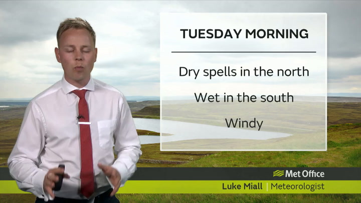
What the Met Office says about this wet weather
A very unsettled spell of weather is expected to affect many parts of England and Wales this week.
Rain and thunderstorms will be particularly intense across southern and eastern parts of England over the next few days.
The Met Office has already issued a series of National Severe Weather warnings out to Thursday, but these warnings are likely to be amended as certainty about impacts increase.
From Tuesday, the very unsettled weather is expected to become more widespread, with warnings of heavy rain extending more widely across England (as far north as the Scottish Borders) and into parts of Wales.
The intense rainfall and thunderstorms for parts of southern and eastern England are being triggered by a combination of heat across parts of central Europe and a low-pressure system approaching the UK from the south.
As the low-pressure system moves closer, it will draw in warmer air from the continent. This combination of warmer, moist air and low pressure provides the ideal conditions for the rapid development of intense rain and thunderstorms.
Steve Ramsdale is duty Chief Meteorologist for the Met Office.
He said:
“The development of weather conditions leading to thunderstorms and intense rainfall can happen extremely quickly, creating a challenge for forecasters. We have been able to indicate the likelihood of further spells of heavy rainfall for the rest of the week, but the exact details will remain uncertain until nearer the events. We will update warnings accordingly, but we urge people to continue to check the forecast and the app for updates during this period.”
There is a chance that heavy prolonged rainfall could lead to local flooding and disruption to transport. The Environment Agency has issued flood warnings.
Away from the warning areas, the rest of the UK should see more settled conditions, especially in parts of Scotland and Northern Ireland.
M48 Severn Bridge restrictions
One lane closed and slow traffic due to strong winds on M48 Severn Bridge in both directions between J2 A466 Wye Valley Link Road (Chepstow) and J1 B4461 (Aust). Matrix sign set to 40 mph.
Lane one (of two) is closed heading into Wales. Lane two (of two) is closed heading out of Wales.
Flooding reported in Standish
Flooding on B4008 in both directions around the Standish Turn off. Traffic is coping well.
Sensors show traffic is able to pass through the area, affecting traffic between Stonehouse and the M5.
Hour-by-hour Gloucestershire weather
This is the latest from the Weather Channel
- 08:00 Cloudy 11C 7C
- 09:00 Cloudy 11C 8C
- 10:00 Cloudy 11C 8C
- 11:00 Cloudy 11C 8C
- 12:00 Cloudy 11C 8C
- 13:00 Cloudy 11C 8C
- 14:00 Few Showers 12C 9C
- 15:00 Few Showers 12C 9C
- 16:00 Showers 12C 10C
- 17:00 Showers 12C 9C
- 18:00 Showers 12C 9C
- 19:00 Showers 11C 8C
- 20:00 Showers 11C 8C
- 21:00 Showers 11C 8C
- 22:00 Showers 11C 8C
- 23:00 Showers 10C 8C
- 00:00 Showers 10C 8C
- 01:00 Showers 10C 8C
- 02:00 Showers 10C 7C
- 03:00 Light Rain 10C 7C
- 04:00 Light Rain 10C 7C
- 05:00 Showers 9C 7C
- 06:00 Showers9C 7C
Met Office weather
This is what the Met Office is forecasting for South West England
Today:
A wet start for many, but the rain will ease and clear westwards through the day. As bright spells develop in its wake so will heavy and perhaps thundery showers, giving some torrential downpours in places. Windy in the west. Maximum temperature 17 °C.
Tonight:
Showers and thunderstorms will slowly ease through the evening with some drier interludes developing.However rain may return to westernmost parts in the early hours, with isolated showers elsewhere. Minimum temperature 7 °C.
Wednesday:
Rather cloudy with showery or longer spells of rain, but with some brighter interludes too. During the afternoon showers may turn heavy and possibly thundery, especially in the east. Maximum temperature 17 °C.
Outlook for Thursday to Saturday:
Staying unsettled throughout. There is the continued risk of heavy showers or longer spells of rain, although with some limited brightness. Winds will be lighter, but remaining cool.