Outdoor writer and photographer Corbet Deary is featured regularly in The Sentinel-Record. Today, Deary writes about Bona Dea Trail.
There are times when I long for solitude. In turn, I strike out to locations that are not easily reached by any other means than by foot. And those who might be aware of these destinations must be prepared to embark upon a long and rugged journey.
In fact, there are a couple of destinations that I rarely share with others. Simply put, they are my special little hideaways, where I feel years away from the hustles and bustles of everyday life, and experience a special closeness to God.
However, I'm usually OK with visiting locations that, although nestled in the seclusion of the forests, are easily accessible. Oft times, these locations are known of by many. And in turn, one is apt to happen upon their fair share of fellow outdoor enthusiasts during excursions.
There are yet other locations, throughout this great state, that are literally situated in the heart of or along the outskirts of towns. But one should not necessarily allow their closeness to civilization to deter a visit. In fact, I can think of a handful of these metropolitan destinations where I find myself returning time and time again.
Bona Dea Trail is one such place. Nestled in 186 acres of Prairie Creek bottomlands, just on the outskirts of Russellville, I often make it a point to allow ample time to stop by and traverse its trails practically every time I plan a trip in the vicinity of the small and quaint college town.
In the neighborhood of 7.5 miles of paved trails meander through the facility, lending to a pleasant and easy journey through a wetland wildlife sanctuary. The designated route consists of a series of interconnecting loops, providing folks with the option of traversing various distances.
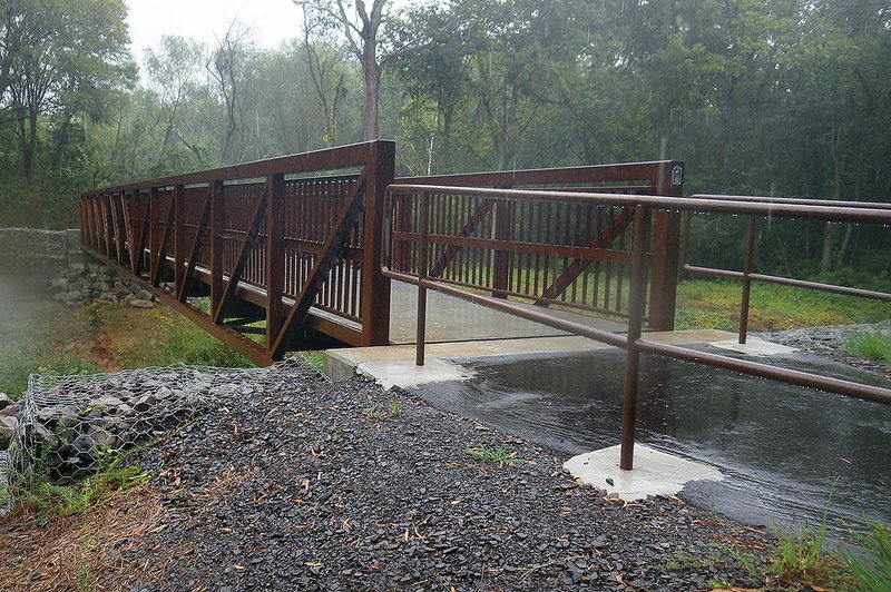
There is plenty to see along this stretch, as the trail system makes its way through a very diverse and interesting habitat. A portion of the paths meanders through forested areas, while other sections cut their way alongside ponds and over creeks. I first visited this particular location probably 10 years ago, and can still recall admiring the bridges spanning the creeks. But I was even more impressed during my most recent visit upon noticing that even more impressive structures have been constructed over these drainage areas.
Not only is the craftsmanship of these new structures worthy of mention, but they are also a surefire indication that this trail system is constantly being maintained.
Although the Bona Dea Trail system is utilized mainly by locals, it also welcomes folks who are visiting the city. And I don't suppose I have ever arrived at the destination when the parking lot was empty. In fact, there was even a fella taking advantage of the paved paths during my recent visit, when I was greeted by a long and steady rainfall.
A good portion of those who utilize the trail system simply travel it via foot, and for good reason. This is a great spot where even those who are not in the best physical condition can get out and enjoy the outdoors. Or one can push the envelope a little farther and embark upon a run.
Of course, this is a popular destination for college students to get out and enjoy a small stint amongst Mother Nature. But the fact that the paths are paved and level deem it a great location for the elderly, as well.
And even those who are confined to walkers and wheelchairs are apt to consider Bona Dea as a potential destination, also, as the designated route is ADA accessible, and can be easily traversed via these apparatuses.
Speaking of getting in shape, the trail system is all about promoting physical fitness. In fact, the trail system features a parcourse. Yep, they sport a complete do-it-yourself fitness program, consisting of 18 exercise stations staggered alongside the path.
I certainly understand hiking along the trail, as one will have the opportunity to take their time and enjoy the pleasant and relaxing atmosphere while walking through a very interesting habitat.
However, I prefer traveling the trail system via bicycle. And the nice thing? This path can easily be traveled with any style of bike. I have ridden my road bike along the path. But I have also ridden my mountain bike on several occasions. And there are those who even make the short and pleasant journey via a recumbent bike.
Regardless of how one chooses to travel, this trail has plenty to see and is a great location where one can get better acquainted with terrain and environment that is noticeably different from what we are accustomed to seeing in the Ouachitas.
And an interesting habitat it is. The Rabbit Run Loop begins at the eastern trailhead and runs through the wood's edge and alongside the highway for a short distance prior to veering away from the road and easing a little farther into a low-lying forested area, and eventually looping back into itself, one mile later.
The Prairie Creek Loop intersects with Rabbit Run and consists of 1.5 miles. The designated route runs alongside a small reservoir referred to as Bullfrog Pond. I would suppose one might hear a bullfrog bellowing on occasion along this particular route. And who knows, one might see an occasional water snake gliding across the water's surface.
The Waldon Way loop winds 2.6 miles during its journey. This is actually my favorite loop of the entire trail system. The path makes its way along the top of a small dam separating Waldon Pond and a black water swamp.
I have stopped at this exact location on a number of times throughout the years. In fact, I can't think of a time when I opted to ignore this stop. It is not uncommon to see wading birds going about their everyday business from this location. And I watched a pair of Canada geese swimming in the pond during my most recent visit.
I have also kicked around the edge of these waterways during the spring and summer months and happened upon a plethora of reptiles and amphibians. But there is yet another reason I always stop at this particular spot. Word is that an alligator actually resides at this facility. And I can't think of a better location for an alligator to be lurking than where a large pond and swamp meet.
The Serendipity Loop meanders 3.5 miles through the flood plain, and lends to yet more opportunities to get acquainted with a diverse and interesting habitat that is hardly a stone's throw from the outskirts of a city.
Yep, the Bona Dea Trail is truly a jewel and is a location where I look forward to visiting again. In fact, I suspect I'll make yet another stop at the facility within the next few months as my travels will likely lead me through Russellville again in the near future.
To get to the Bona Dea Trail from Hot Springs, take Highway 7 north to Russellville and take a left onto Lakefront Drive just before reaching I-40. Travel a few hundred feet and the parking area will be located on the left.
Local on 10/24/2019