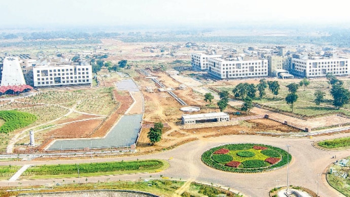
The rise of Naya Raipur
Earlier, one would invoke Chandigarh when it came to planned township. Today, the template has changed. Naya Raipur is fast emerging as a role model for developing cities, with Andhra Pradesh taking cue from it to develop its own capital in Amravati, and Jharkhand planning one in the near future.

Earlier, one would invoke Chandigarh when it came to planned township. Today, the template has changed. Naya Raipur is fast emerging as a role model for developing cities, with Andhra Pradesh taking cue from it to develop its own capital in Amravati, and Jharkhand planning one in the near future.
Naya Raipur, the idea for which first came up in 1973, is serving as the administrative capital of Chhattisgarh and catering to the infrastructural needs of industry and trade in the region. The planning and growth of Naya Raipur stands as a significant benchmark in rapidly urbanising India and among the green field cities planned globally in the 21st century.
Naya Raipur, which has been developed under the Narendra Modi government's 'Smart City Mission', has now blossomed into a world-class city with state-of-the-art infrastructure that also bring in social cohesion and local inclusiveness. It sets a precedent of how urban development should be initiated and implemented.
Naya Raipur Development Plan 2031 was prepared with a vision to develop a 'Green City', equipped with modern amenities for residents and visitors. The city is wellplanned, with balanced distribution of landuse and acts as the engine of economic growth for Chhattisgarh.
The development plan covers a total area of 237.42 sq km, out of which the core area alone spreads over 95.22 sq km. The targeted population for the city is 5,60,000 by 2031. The plan for 2031, prepared in 2008, encompasses 41 revenue villages. The planning area of Naya Raipur is distributed into three layers. The form of Naya Raipur was deliberately designed linear in shape to facilitate Mass Rapid Transit System (MRTS) movement and ease in planning of infrastructure and facilities.
THE GREEN PLAN
Crisscross green walkways have been proposed and are connected from one end of the city to the other to promote pedestrian andnon-motorised transportation (NMT) movement. The green belt of 500m width around Layer-I boundary acts as a natural air purifier for the city.
All water bodies have been retained and even the smallest ones, including natural streams, ponds and lakes, have been provided with a buffer of 25 m. Keeping the climatic conditions in mind, detailed natural drainage analysis based on the sustainable urban drainage system (SUDS) model has been prepared to retain water in streams, ponds and lakes throughout the year, using the water front for urban activities.
HOUSING & INFRASTRUCTURE
The planning of the city is expected to accommodate housing for EWS and LIG with 25 per cent of area in the residential sectors reserved for the above economic classes. The infrastructure has been created utilising state-of-the-art technologies yet conserving the natural resources. NRDA has envisaged the development of the city on self-sustainable financing model.
Various infrastructure projects like city level water supply, logistics hub and real estate projects like hotel, golf course, themed township, sports city, etc, are being developed.
The infrastructure was envisioned as Information and Communication Technology-friendly in the development plan itself and subsequently, when Smart City initiative was introduced by the Government, the adaptation to the same was easily materialised.
For Smart City implementation, Geographic Information System (GIS) mapping of all utilities and addition of SCADA (Supervisory control and data acquisition) system is being done.
TRANSPORTATION SYSTEM
The transportation network for NRDA was based on the concept of accessibility, affordability, equitable and safe mobility. The 100-km of four and six lane city level roads have been constructed with 55-km of LED street-lighting.
A 20m wide median is proposed in most of the roads with a vision of future expansion.
A railway line has been planned and implemented connecting Naya Raipur to the main rail network within the country.
Four railway stations within the planning boundary of NRDA will provide access to most of the sectors and villages. Other ongoing projects are Public Bike Sharing Scheme, Multimodal Logistics Hub and Last Mile Connectivity with e-IPT.
POWER & WATER SUPPLY
The focus has been to make power supply available 24x7, reduce transmission and distribution loss. NRDA intends to increase in renewable energy resources (20 per cent power supply at Mantralaya is through solar energy) and continue to achieve more in this sector.
Some of the key features of the smart energy system are to reduce redundancy, underground cable network, solar panels, wind-powered streetlights, intelligent streetlight management system, smart meters and electrical charging stations.
A water treatment plant has been set up and treated water is being supplied to the residents since 2015. The existing system is being upgraded and the SCADA system is being set up to increase the system efficiency by future provision of 24x7 fully pressurised water supply system, real-time monitoring, automatic meter reading and its integration with billing software.