Rain and snow likely to break California’s most enduring Thanksgiving tradition: perfect weather
Trolling the East Coast and Midwest with tales of Thanksgiving dinner while wearing shorts under sunny skies is a California tradition.
But this year is going to be different.
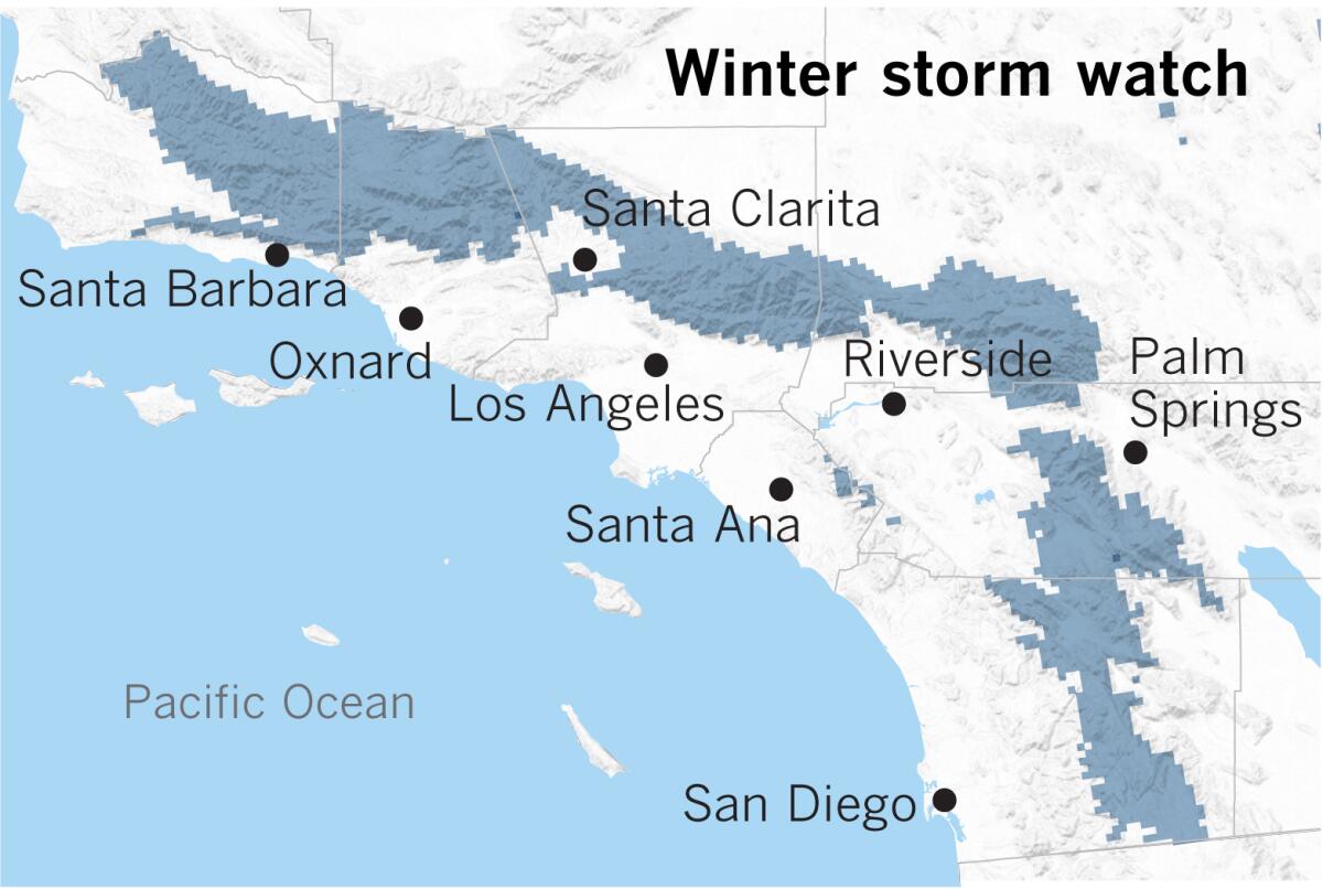
Forecasters are warning of a stormy Thanksgiving holiday week marked by rain across the state and snow levels so low in elevation they could close major freeways like Interstates 5, 15 and 80. The storm is expected to bring such cold temperatures that snow may accumulate even on the floor of high-desert cities such as Lancaster, Hesperia and Barstow. Up to 2 feet of snow could hit Big Bear and Wrightwood and up to 4 feet around Lake Tahoe and Mammoth.
The forecast has holiday travelers checking their plans and hosts fretting about whether turkey al fresco for 20 could end in disaster. Just two years ago, Los Angeles sat down to a Thanksgiving feast just after the high temperature hit a crispy 92 degrees — an all-time record. This year, San Diego could be facing one of its coldest Thanksgivings since records began being kept in 1874, with a forecast high of just 60 degrees.
“Everybody can definitely break out their Uggs and Lands’ End parkas,” climatologist Bill Patzert said. L.A.’s high temperature on turkey day could remain in the 50s; San Francisco, possibly in the 40s.
And with rain probably persisting in Southern California into Thanksgiving evening, with a slight chance of thunderstorms, the holiday week might lead to the discovery of new roof leaks.
“Put your water buckets next to your turkey,” Patzert said.
But as you imagine a rain-slicked ride to your holiday dinner or a soggy drumstick, there is something positive to say about the wet Thanksgiving forecast. “This could put an end to the fire season. This is large enough, if it delivers,” Patzert said.
Much of California has been abnormally dry so far this autumn, leaving vegetation tinder dry and threatening to keep fire danger high until rains arrived. Some of California’s most recent destructive fires have hit during November and December while rainfall has been absent, such as the Camp fire that ignited on Nov. 8, 2018, destroying much of the town of Paradise and killing 86 people, and the Thomas fire in Ventura and Santa Barbara counties, which began on Dec. 4, 2017, burning more than 1,000 structures and killing two.
Fire danger continued on Monday, with a fast-moving brush fire threatening numerous homes in Santa Barbara. The Cave fire was being pushed down from Los Padres National Forest toward communities by powerful winds. Highway 154 was closed, and officials were dealing with spot fires breaking out dangerously close to homes. Firefighters are hoping they can hold off the blaze until the rains arrive.
Until this storm, the fall of 2019 has been among the top five driest starts to the water year across Northern California, which began Oct. 1, said Nina Oakley, regional climatologist for the Western Regional Climate Center in Reno.
Sacramento has reported no measurable precipitation between Oct. 1 and Sunday — a parched situation that has occurred in only four other years since records began being kept in 1877, Oakley said. San Francisco has seen only 0.03 inches in the same time period.
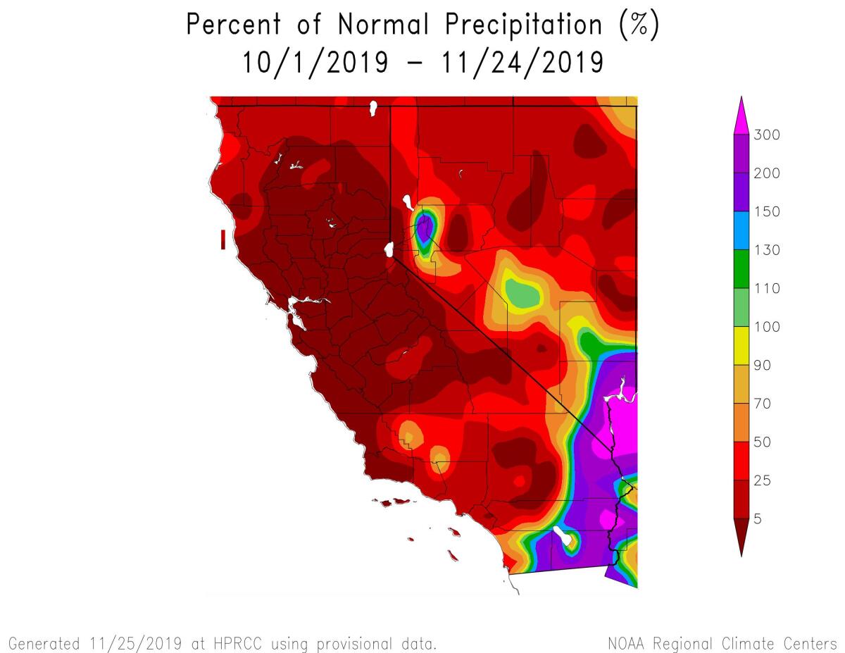
“It’s not unprecedented to have fires in November or even December in parts of Southern California, but it really is in far Northern California,” said Daniel Swain, a climate scientist with UCLA and the National Center for Atmospheric Research. “This is already pretty much the latest fire season I think that anyone can remember in the northern part of the state.”
Los Angeles has seen just 42% of the average of 1.48 inches expected by this point in the water year.
Unfortunately, scientists say drier autumns and later starts to fall rains are a trend in California’s future, which is expected to worsen with climate change.
How this rainy season will fare for California is hard to say. At this point, the chances of a rainier-than-average or a drier-than-average winter are basically a toss-up, Patzert said.
The winter weather will begin hitting California on Tuesday, as a weather phenomenon known as a bomb cyclone will develop off the West Coast. A bomb cyclone refers to a low-pressure system that quickly strengthens, Swain said.
Strong winds are expected on the far northern edge of California on Tuesday, with gusts of 72 mph forecast in Weed, 66 mph in Crescent City and 53 mph in Eureka. With waves breaking as high as 35 feet along the coast, there’s a risk of extensive coastal erosion in many areas; hail is also a risk through Wednesday.
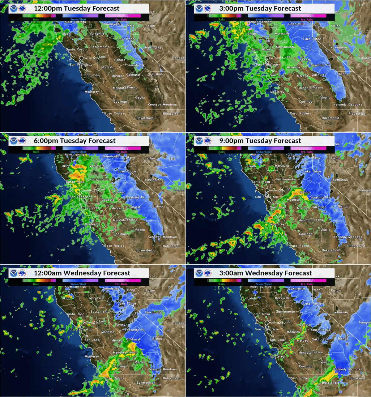
The season’s first major snow will make its first landfall in the Sierra Nevada on Tuesday afternoon, with most of it falling Tuesday night and Wednesday. Forecasters are highly discouraging travel into the northern and central California mountains after Tuesday midday all the way through Thanksgiving afternoon. “Thursday, it won’t be as bad, but it will still be snowy and not fun,” said Karleisa Rogacheski, meteorologist with the weather service’s Sacramento office.
All roads to the Lake Tahoe and Mammoth ski resorts could be be difficult or impossible to travel on between Tuesday and Thursday, including Interstate 80 and U.S. Routes 50 and 395.
The San Francisco Bay Area is forecast to start seeing rain Tuesday afternoon, with showers tapering off by Thanksgiving. Forecasters issued a flash flood watch in northern Sonoma County for the area burned in the Kincade fire for Tuesday afternoon and evening.
Central California was already dealing with difficult weather conditions Monday ahead of the winter storm, with strong winds blowing over a big rig on Highway 58 in Kern County. Wind-blown dust storms may have triggered a multiple-vehicle accident on Highway 41 in Fresno County.
Snow is expected to snarl traffic in the Southern California mountains Wednesday.
Starting Wednesday night and ending Friday, up to 6 inches of snow could fall along the Grapevine section of Interstate 5. Alternative routes on Highways 14 and 58 could also be hit with snow.
Even areas unaccustomed to winter weather — such as Highway 152, often used by motorists traveling between San Jose and Interstate 5 in the Central Valley — could see snow Tuesday through Thursday.
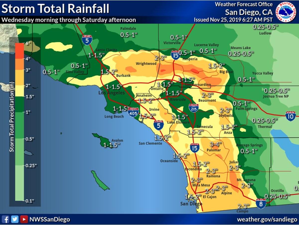
In the Los Angeles area, steady rain was expected to start late Tuesday night into Wednesday morning. Potential thunderstorms are possible Wednesday night into Thursday. The coast and valleys could get 1 inches to 2 inches of rain.
The weather may be more severe for Orange and San Diego counties and the Inland Empire, where the weather service has called for a flash flood watch. Rainfall amounts could be up to 3 inches in areas east of San Diego and east of Riverside — stronger than L.A., because the low-pressure system from the northwest will be colliding with a small atmospheric river sliding from the southwest.
Travel into ski resorts in the Big Bear and Wrightwood areas will face trouble starting Wednesday. “It’s not going to get any better on Wednesday night or Thanksgiving Day,” warned meteorologist Mark Moede of the weather service’s San Diego office. “It’s actually going to get colder and the snow levels are going to fall even lower.”
The big question for many might be: Will it actually be raining when Thanksgiving dinner is served? That is hard to say. In the L.A. region, at least, most of the raindrops from this storm are expected to fall Wednesday and into Thursday morning, but scattered showers are still expected through Thanksgiving night and into Friday, said Keily Delerme, meteorologist with the weather service’s Oxnard office.
Lin reported from San Francisco, Fry from Los Angeles.
More to Read
Start your day right
Sign up for Essential California for news, features and recommendations from the L.A. Times and beyond in your inbox six days a week.
You may occasionally receive promotional content from the Los Angeles Times.
