


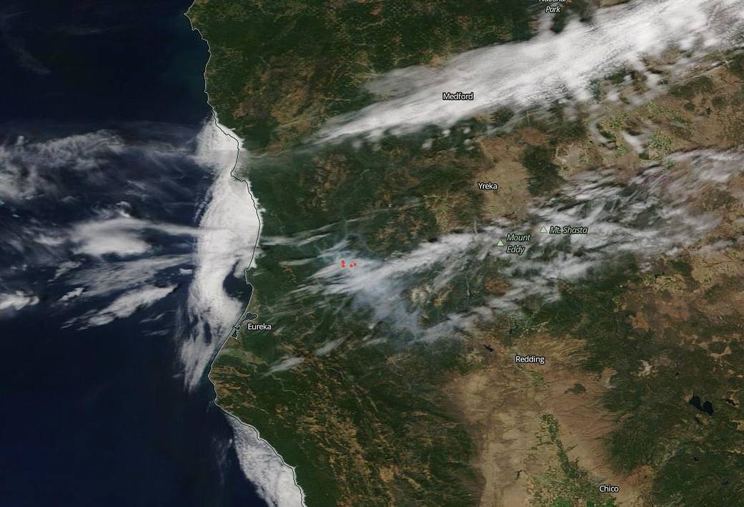
NASA’s Aqua satellite using the MODIS instrument (Moderate Resolution Imaging Spectroradiometer) captured this image of the Red Salmon Complex fire on August 13, 2020. The Red Salmon Complex fire, located 14 miles northeast of Willow Creek, Calif. in the northern part of the state, began as two separate fires–the Red fire and the Salmon fire. Each of these fires started with a lightning strike on June 27, 2020. They merged together and became the Red Salmon Complex with containment measures encompassing both fires. The complex is burning in rugged remote portions of the Trinity Alps Wilderness. The Salmon fire is on the Shasta-Trinity National Forest near Salmon Mountain; the Red fire is the in the Red Cap drainage east of Black Mountain on the Six Rivers National Forest. The fire complex is 8,025 acres and 35% contained as of the latest update on Inciweb.
Weather conditions continue to assist fire growth rather than fire suppression as drier air from the low pressure system and persistent inversion will result in poor humidity recovery tonight with cooler temperatures. A warming trend returns Friday and Saturday (Aug. 14 and 15) which is expected to increase fire activity. Smoke of “Unhealthy” levels continue to affect Forks of Salmon and areas near the fire. Communities along the Bigfoot Highway such as Orleans, Weitchpec and Hoopa could expect to see smoke settle in midday and potentially reach “Unhealthy” levels for brief periods as well. For more on Air Quality from the fires visit: fires.airfire.org/outlooks/NWCalifornia
NASA’s satellite instruments are often the first to detect wildfires burning in remote regions, and the locations of new fires are sent directly to land managers worldwide within hours of the satellite overpass. Together, NASA instruments detect actively burning fires, track the transport of smoke from fires, provide information for fire management, and map the extent of changes to ecosystems, based on the extent and severity of burn scars. NASA has a fleet of Earth-observing instruments, many of which contribute to our understanding of fire in the Earth system. Satellites in orbit around the poles provide observations of the entire planet several times per day, whereas satellites in a geostationary orbit provide coarse-resolution imagery of fires, smoke and clouds every five to 15 minutes. For more information visit: https://www.nasa.gov/mission_pages/fires/main/missions/index.html
NASA’s Earth Observing System Data and Information System (EOSDIS) Worldview application provides the capability to interactively browse over 700 global, full-resolution satellite imagery layers and then download the underlying data. Many of the available imagery layers are updated within three hours of observation, essentially showing the entire Earth as it looks “right now.” Actively burning fires, detected by thermal bands, are shown as red points. Image Courtesy: NASA Worldview, Earth Observing System Data and Information System (EOSDIS). Caption: Lynn Jenner with information from Inciweb and from the U.S. Forest Service – Six Rivers National Forest Facebook page
For more information about the National Forests impacted by the fires, visit: Shasta-Trinity National Forest and the Six Rivers National Forest