Pressure is on the rise across the country, so settled weather will be the norm during the coming days.
Pressure continues to rise slowly, with the weather now settled over the bulk of the country. So, if the adage 'quick rise soon past, slow rise long last' is true, there should little in the way of wet and windy weather for some time. Although mainly dry and quieter, most parts are fair rather than fine as like yesterday; we will be chasing the cloud around.
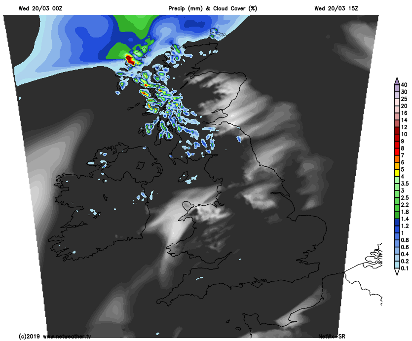
There's lots of cloud this morning that's thick enough to give a little light rain or drizzle, this mostly in the West and towards coasts of North East England at first, but for the bulk of the country, it's dry. The best of the cloud breaks at the moment are across the Midlands, but even here large amounts of thin high cloud will make any sunshine quite milky. During the afternoon an approaching front will bring heavier bursts of rain to the Northern Isles and the North of Scotland, but elsewhere it'll remain much the same in a dry but often disappointingly cloudy day. The cloud will break in a few places though, with districts around the Moray Firth, the Welsh borders and the East and South East of England most likely to see these.
A South West wind will be moderate or fresh across Northern Ireland and most of Scotland, freshening further across Highland and the far North of Scotland, where gales are likely later. Over England and Wales, winds will be lighter, making it pleasantly warm by the afternoon where the sun comes through. Top temperatures of 11 to 13C in the North and 14 to 16 locally 17C in the East and South will be somewhat above normal for the start of astronomical spring.
Districts to the North of the Great Glen and perhaps the far North and West of Northern Ireland see further occasional rain after dark, probably with heavier bursts in a stiff South West wind that should moderate a little later in the night. Elsewhere it'll be less windy and mainly dry, with much lighter breezes in the South. Cloud amounts will remain quite large, but some clear spells are likely mostly East of the Pennines and in the South. Here it could turn chilly with perhaps a few mist or fog patches towards dawn, but it's not expected to be a cold night, with minimum temperatures mostly in the range 5 to 8C.
High pressure keeps England and Wales mainly dry on Thursday, but there'll continue to be stubborn cloud drifting about. There will be breaks through to give some sunshine with the best of these probably to the East of the Pennines, to the lee of the Welsh mountains and across central and southern parts. This'll make it a rather warm afternoon in a mostly light or moderate South West wind, with top temperatures between 14 and 17C depending on cloud cover.
Across Northern Ireland and Scotland, a weak trough will generally give large amounts of cloud and some patchy mostly light rain or drizzle, with the best of any sunshine towards Lothian and The Borders and in the far North. Places around the Moray Firth could have a fine afternoon, but it won't be a mild as yesterday, with top temperatures across Northern Ireland and Scotland mostly in the range 10 to 13C.
A more potent system could bring heavier rain to Northern Ireland and the North and West of Scotland after dark. Elsewhere it should continue mainly dry, although still with variable amounts cloud. It'll turn misty in places and with a South West wind lighter across central and southern parts of England, patchy fog could form once more towards dawn. Although perhaps turning chilly over parts of the South it'll be a relatively mild night again in most regions, with lowest temperatures mostly between 4 and 8C.