

As heavy rain pounds the Charleston area early Sunday morning, the National Weather Service cautioned the worst of the storms may come later in the day.
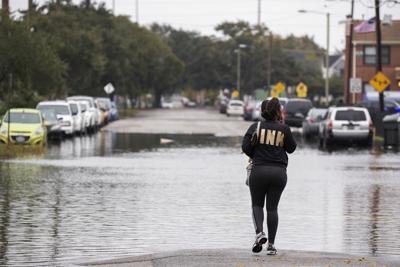
Flooding began in the morning, as some of downtown Charleston's typical spots pooled with water.
Flood advisories for Charleston and Dorchester counties continued to be extended through the morning. Two to three inches of rain have already fallen in many areas, according to the National Weather Service. Another 1 to 2 inches is expected.
Experts predicted "minor flooding of low-lying and poor drainage areas."
Meanwhile, the City of Charleston decided to cancel its Tree Lighting Ceremony in Marion Square, initially scheduled for 4:30 p.m. The weekend's holiday parade was also rescheduled yesterday, given the conditions expected Sunday. The city at first narrowed the hours for the Holiday Farmers Market, then canceled that event as well.
The National Weather Service advised thunderstorms would move east toward the coast through the afternoon, and would be at their worst between 2 p.m. and 9 p.m.
Hail, 60 mile-per-hour winds and even isolated tornadoes are possible. But the worst of the weather will likely be felt farther west of Charleston, toward the I-95 corridor, according to an advisory posted close to 4 a.m. this morning.
A cold front could also be close behind.


