Calendar An icon of a desk calendar. Cancel An icon of a circle with a diagonal line across. Caret An icon of a block arrow pointing to the right. Email An icon of a paper envelope. Facebook An icon of the Facebook "f" mark. Google An icon of the Google "G" mark. Linked In An icon of the Linked In "in" mark. Logout An icon representing logout. Profile An icon that resembles human head and shoulders. Telephone An icon of a traditional telephone receiver. Tick An icon of a tick mark. Is Public An icon of a human eye and eyelashes. Is Not Public An icon of a human eye and eyelashes with a diagonal line through it. Pause Icon A two-lined pause icon for stopping interactions. Quote Mark A opening quote mark. Quote Mark A closing quote mark. Arrow An icon of an arrow. Folder An icon of a paper folder. Breaking An icon of an exclamation mark on a circular background. Camera An icon of a digital camera. Caret An icon of a caret arrow. Clock An icon of a clock face. Close An icon of the an X shape. Close Icon An icon used to represent where to interact to collapse or dismiss a component Comment An icon of a speech bubble. Comments An icon of a speech bubble, denoting user comments. Comments An icon of a speech bubble, denoting user comments. Ellipsis An icon of 3 horizontal dots. Envelope An icon of a paper envelope. Facebook An icon of a facebook f logo. Camera An icon of a digital camera. Home An icon of a house. Instagram An icon of the Instagram logo. LinkedIn An icon of the LinkedIn logo. Magnifying Glass An icon of a magnifying glass. Search Icon A magnifying glass icon that is used to represent the function of searching. Menu An icon of 3 horizontal lines. Hamburger Menu Icon An icon used to represent a collapsed menu. Next An icon of an arrow pointing to the right. Notice An explanation mark centred inside a circle. Previous An icon of an arrow pointing to the left. Rating An icon of a star. Tag An icon of a tag. Twitter An icon of the Twitter logo. Video Camera An icon of a video camera shape. Speech Bubble Icon A icon displaying a speech bubble WhatsApp An icon of the WhatsApp logo. Information An icon of an information logo. Plus A mathematical 'plus' symbol. Duration An icon indicating Time. Success Tick An icon of a green tick. Success Tick Timeout An icon of a greyed out success tick. Loading Spinner An icon of a loading spinner. Facebook Messenger An icon of the facebook messenger app logo. Facebook An icon of a facebook f logo. Facebook Messenger An icon of the Twitter app logo. LinkedIn An icon of the LinkedIn logo. WhatsApp Messenger An icon of the Whatsapp messenger app logo. Email An icon of an mail envelope. Copy link A decentered black square over a white square.

Plans lodged for last part of Speyside Way extension – and it’s about to get much tougher

Post Thumbnail

One of the north’s most famous walks is about to get officially tougher – by 15 miles.

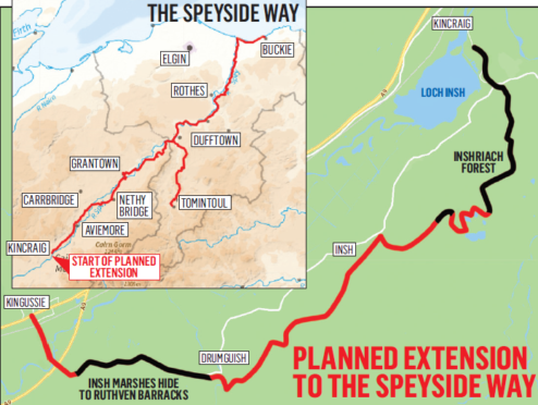
Plans have been lodged for the final phase of the Speyside Way extension project which will create an 80-mile walking route between the Moray coast and the Cairngorms.

Outdoor Access Trust for Scotland have submitted plans to build the 0.75-mile footpath between Insh Marshes Hide at Torcroy and Ruthven Barracks, near Kingussie.

It will create the final part of the 15-mile extension project to the south of Aviemore which has been ongoing since 2005.

Peter Crane, head of visitor services at the Cairngorms National Park Authority, the lead body on the extension project, said the hope is to complete the final section of the route by summer next year.

And he said an existing off-road cycle way will link the route from Kingussie to Newtonmore.

He said: “There has always been a strong desire from the community to extend the path to Newtonmore, and we are very confident we will get there now.”

The Speyside Way is one of four official long distance routes in Scotland and was first opened in 1981, to run from Spey Bay to Ballindalloch, and was extended over the years to reach Aviemore by 2000, creating a 65-mile route.

As it stands, the Speyside Way starts in Buckie and finishes just outside Kincraig.

Three earlier phases to the extension project have been completed after various delays over an objection to run the route through the Kinrara Estate.

The final phases of the £1.1 million extension project will involve developing a further 4.7 miles between Kincraig and Kingussie and the destination of this latest extension will be Ruthven Barracks.

Planning consent and funding is already in place to build a 1.2 mile section through Inshriach forest to the south of Kincraig, linking it up to existing footpaths. This is due to start in the autumn.

Further work is needed to link Ruthven to Kingussie once this part of the A9 is dualled.

When complete the Speyside Way will effectively run for 80 miles between Buckie and Newtonmore.

Mr Crane added: “One of the things we have really tried to do is to make sure the walks links people from Kingussie to Aviemore.

“We want our residents and visitors to be able to use these short connections as much as people doing the long distance route.”

He said that 80% of visitors to the national park area come by car, with 16% wanting to walk or cycle for function.

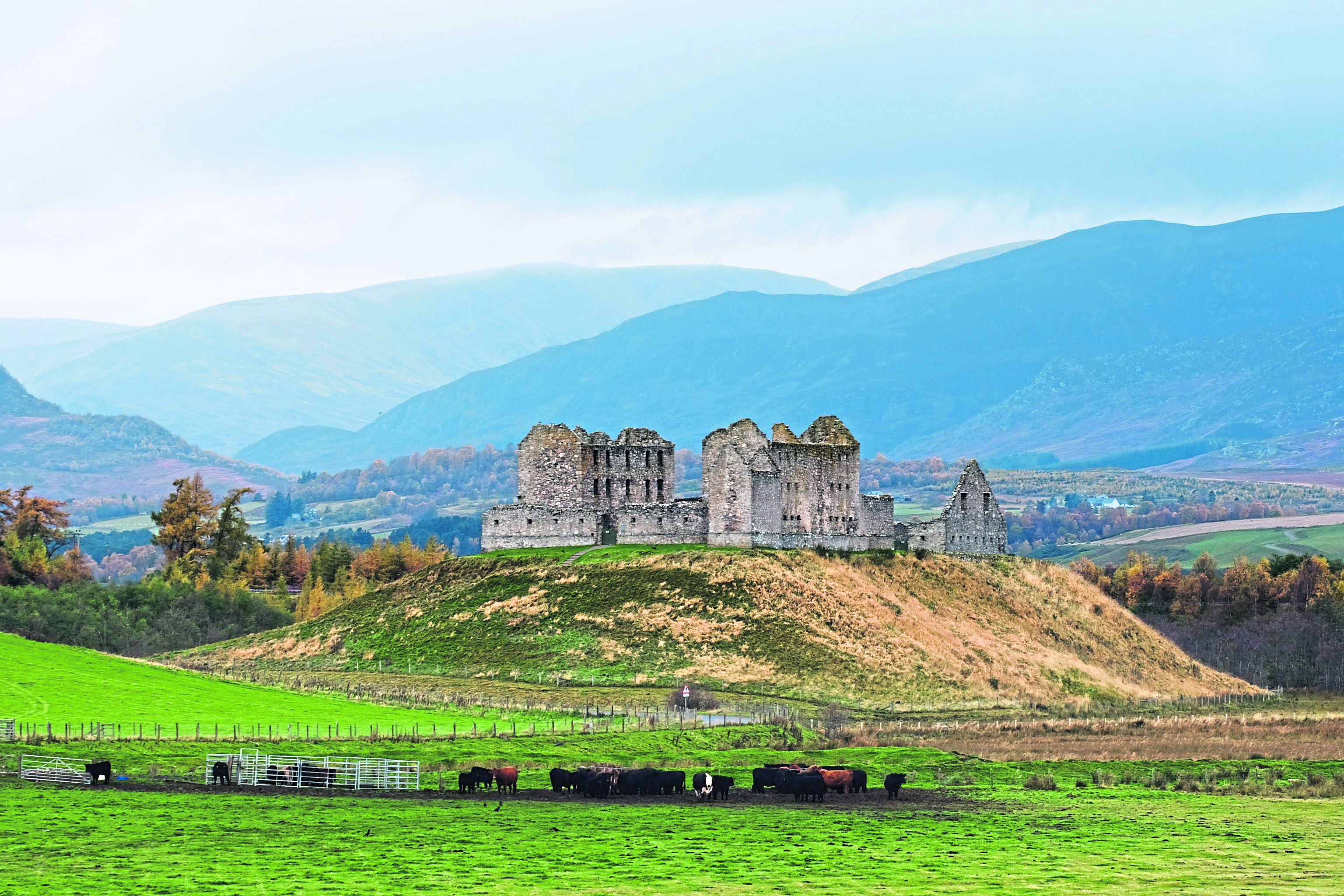
The Speyside Way extension will provide off-road links to various popular visitor attractions such as Loch Insh Watersports, Insh Marshes National Nature Reserve and the Ruthven Barracks and Highland Folk Museum.

The CNPA is also looking at making future improvements to the route east of Aviemore.