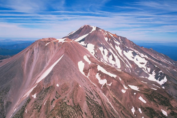
When French explorer Jean-François de Galaup, comte de La Pérouse, and his crew were sailing along the coast of northern California on September 7, 1786, they spotted a smoky plume in the sky that looked like volcanic ash. The ship’s cartographers marked a volcanic eruption on their maps of the region.
But volcanologists have puzzled over the plume. They have never found ash deposits that matched the eruption’s proposed dates, and no other records detailing the alleged eruption have surfaced. This month, a team of scientists and historians doing a bit of detective work concluded the plume was not caused by a volcano but likely a grassland fire. So on August 6, Mount Shasta’s volcanic history became a little shorter when the 1786 eruption was officially struck from the record.
The volcanic housecleaning is part of a larger effort led by database manager Ed Venzke of the Smithsonian Institution’s Global Volcanism Program. He and his colleagues work to fact-check historical accounts of eruptions around the world. Sniffing out inaccuracies in these records can improve scientists’ understanding of a volcano’s behavior and activity. The strength and type of a past eruption offers clues about how future events might threaten certain areas; false records can throw those predictions off.
On supporting science journalism
If you're enjoying this article, consider supporting our award-winning journalism by subscribing. By purchasing a subscription you are helping to ensure the future of impactful stories about the discoveries and ideas shaping our world today.
Venzke and his team often rely on fieldwork conducted by geologists to confirm historical records. Volcanologists at the U.S. Geological Survey’s California Volcano Observatory have spent decades mapping Mount Shasta’s geologic history. When it came to rocks dated to 1786, no evidence of lava or debris flows ever turned up. So Jessica Ball, a volcanologist at the observatory, turned to archival documents for more clues. Among those articles was an annotated bibliography on the history of Mount Shasta written by cultural historian William Miesse, formerly a lecturer at the College of the Siskiyous, who was also dubious about the veracity of the 1786 explosion.
Miesse traced the first association of Mount Shasta with La Pérouse’s plume back to a single article written in 1930 by volcanologist R. H. Finch. The article has since been cited in research papers and textbooks and is still taught in many classrooms today. “It's a wonderful example of how mistakes and errors perpetuate once they get in print,” Miesse says.
He nailed the mistake when he traveled to the French National Archives in Paris to study the original map La Pérouse commissioned. The tattered, sepia-toned chart showed the California coast in exquisite detail. “There was only one thing in color, and it was a little volcano righton” Cape Mendocino, which juts into the sea about 100 miles south of the Oregon-California border, Miesse says. “[The map] had this wash of violet smoke traveling down the coastline.”
That location made it clear the explorers had not been looking at an eruption. “The map’s details do show a volcano, but they show it right on the coast, where there are clearly no volcanoes,” Ball says. Nearly all of California’s 16 volcanoes sit nestled along mountain ranges far inland.
If La Pérouse’s crew did not witness a volcanic eruption, what did it see? Miesse, Ball and Venzke suspect that the people on the ship probably witnessed a grass fire, possibly set by indigenous tribes in the region. Witnesses often mistake a wildland fire’s smoke for volcanic ash, Venzke says—to the untrained eye, the often dark plumes look similar. At other times, observers have seen clouds of dust and dirt kicked up by a big landslide and assumed they were an eruption.
Mount Shasta is not the only volcano to lose a big bang. By combing through ships’ logs, old research papers and travel diaries, Venzke and his colleagues have debunked and discredited 166 supposed explosions, including false eruptions at Mount Etna in Italy, Deception Island off the coast of Antarctica and Mount Unzen in Japan.
An accurate understanding of when and how a volcano has erupted helps predictions of potential future blow-ups. “You don’t have any hope of understanding what’s coming if you don’t at least figure out what happened in the past,” Venzke says. Emergency managers use historical eruption information to develop hazards assessments for volcanoes across the country. This work helps officials better allocate resources, such as volcano-monitoring instruments that track seismicity and volcanic gas emissions. Improved knowledge also lets officials spend less time and money on mountains that may not pose a looming threat. “If we can say for sure that a volcano hasn’t erupted in the past 2,000 years or so, then maybe it’s more important to focus on a different volcano,” Ball says.
Even with one eruption erased, Mount Shasta is still a cause for worry. In 2018 the USGS updated its list of the most hazardous volcanoes in the country. Mount Shasta ranked fifth out of the list’s 18 “very high threat volcanoes” because of several recent undisputed events. “It has had young eruptions by geologic standards, and we know there is magma in its plumbing system,” Ball says.