
Updated on July 18, 2019: Vigorous Monsoon to give very heavy rains over Kerala, Coastal Karnataka
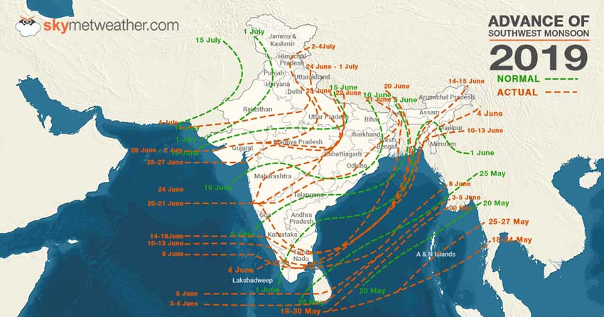
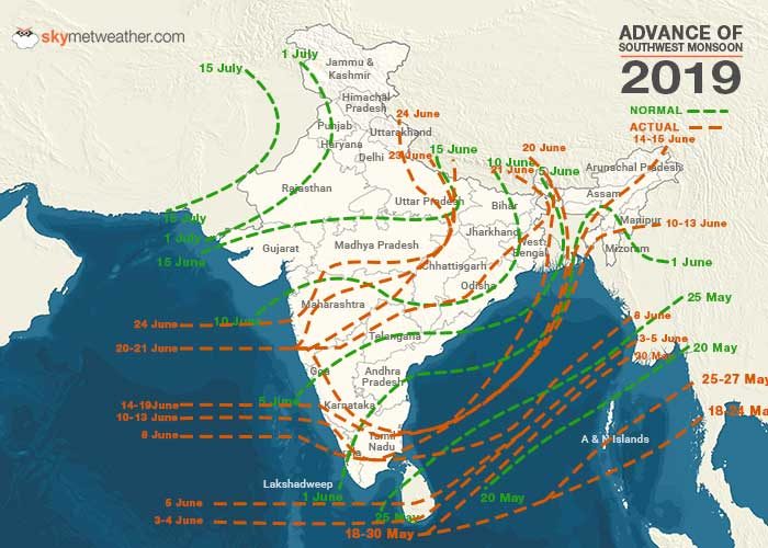
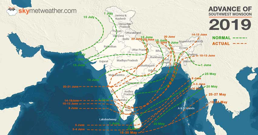
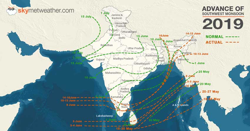
The Northern Limit of Monsoon is now passing through Barmer, Jodhpur, Churu, Hanumangarh, and Sri Ganganagar.
Monsoon is expected to be vigorous over many parts of Kerala during the next 24 to 72 hours. On the other hand, rains will also be heavier over Coastal Karnataka.
In the next three to four days, rains will also be seen over South Interior Karnataka as well as Lakshadweep in the coming three to four days.
Updated on July 15, 2019: Monsoon advances further, misses deadline to cover entire country
Southwest Monsoon has further progressed and covered most parts of Haryana and Punjab today. With this, Monsoon 2019 has now missed the deadline of covering the entire country i.e. July 15. There are still few parts of Punjab, Haryana and West Rajasthan left.
The Northern Limit of Monsoon (NLM) is now running through Latitude 25°N/Longitude 60°E, Latitude 25°N/Longitude 65°E, Barmer, Jodhpur, Churu, Ferozpur and Latitude 31°N/Longitude 74.5°E.
However, with rains in offing, we expect Monsoon 2019 to reach its last post soon.

Updated on July 14, 2019: Heavy rains continue to lash parts of Dehradun, Nainital, Bihar, Assam
Widespread rainfall with heavy to very heavy and isolated extremely heavy spells are likely to continue over Assam and Meghalaya during the next 24 hours and decrease thereafter.
The remaining parts of northeastern states and Sub-Himalayan West Bengal and Sikkim are likely to experience heavy to very heavy rainfall during the next two to three days.
Updated on July 12, 2019: Break-Monsoon conditions to take over India, heavy rains to confine to Himalyan foothills and Northeast India
Country is heading towards break-Monsoon conditions, weather conditions are slowly and steadily getting aligned for the same. Rains have already reduced from most parts of the country, barring foothills of Himalayas, Northeast India and West Coast.
In the coming days i.e. at least for next 4-5 days, heavy rains to remain confined to Uttarakhand, foothills of Himalayas of East Uttar Pradesh, North Bihar, Sub-Himalayan West Bengal & Sikkim, Assam, Arunachal Pradesh and Meghalaya. Along with this, some good spells with isolated heavy rains can be seen along the West Coast, particularly over Coastal Karnataka and South Konkan & Goa.
In view of this, flood situation will remain grim over the parts of East and Northeast India. Assam would not see much relief in terms of weather in the coming days.
Updated on July 11, 2019: Flooding rains in Uttar Pradesh, parts of Bihar, Assam and Meghalaya to continue
Vigorous Monsoon conditions continued to give incessant rains over Uttar Pradesh, parts of Bihar and Meghalaya. All the states have recorded three-digit rainfall, wherein Lucknow recorded 122 mm of rains, Bareilly 112 mm, Bahraich 105 mm, Shahjahanpur 101 mm, Varanasi 104 mm, Pasighat 125 mm, and Chapra 123 mm.
In fact, with well-marked low pressure area prevailing over East Uttar Pradesh and adjoining Bihar would keep conditions conducive for heavy to very heavy rains, with few extremely heavy rains during the next 24 hours.
Flooding have already made an appearance over few areas of these neighbouring states and we expect situation to become more grim during the next 24 hours.
Updated on July 10, 2019: Vigorous Monsoon to give more torrential rains in East and Northeast, floods threat looms large
Monsoon 2019 remained vigorous over East and Northeast India, giving torrential rains over the region. In span of 24 hours from 8:30 am on Tuesday, Bahraich recorded 202 mm of rains, Gorakhpur 114 mm, Bhagalpur 102 mm, Pasighat 112 mm, and North Lakhimpur 105 mm.
These torrential Monsoon rains have triggered looking flooding in parts of Uttar Pradesh and Bihar, while Assam has once again came under the clutches of floods.
For the next 2-3 days also, we do not see any relief from the ongoing weather conditions. According to Skymet Weather, a well-marked low pressure area is marked over East Uttar Pradesh and a trough running through this system till Northeast India. Both the systems would keep the weather conditions conducive for incessant rains to continue for the next 2-3 days.
Several places would continue to record 3-digit Monsoon rainfall during this time span. With this, threat of floods, landslide and mudslide looms large over the above mentioned region.
Updated on July 9, 2019: Monsoon covers more parts of Haryana, Punjab and Rajasthan, to wrap entire India in time
In wake of active Monsoon conditions over central and northwestern parts of the country, the Southwest Monsoon 2019 has progressed further and has now covered entire East Rajasthan and Haryana. It has also covered more parts of Punjab and West Rajasthan.
Again, it was only the eastern end of the Monsoon that has advanced further, while the western arm remained stagnant.
The Northern Limit of Monsoon (NLM) is now running through Latitude 25°N/Longitude 60°E, Latitude 25°N/Longitude 65°E, Barmer, Jodhpur, Churu, Ludhiana, Kapurthala and Latitude 33°N/Longitude 74.5°E.
Weather conditions remained favourable for Southwest Monsoon to even cover the last post of the country i.e. West Rajasthan very soon in the coming week. Although Monsoon made a late start, followed by sluggish advancement but it seems to cover the country in time. Usually, the Monsoon covers the entire country by July 15.
Updated on July 6, 2019: Monsoon 2019 covers entire Delhi, Uttar Pradesh, parts of Punjab and Haryana
The Northern Limit of Monsoon (NLM) continues to pass through Latitude 25°N/Longitude 60°E, Latitude 25°N/Longitude 65°E, Barmer, Jodhpur, Sikar, Rohtak, Chandigarh, Una, and Amritsar.
Conditions are becoming favourable for further advance of Southwest Monsoon into remaining parts of Haryana, Punjab and some more parts of Rajasthan during the next 48 hours.
Updated on July 4, 2019: Monsoon 2019 covers entire Gujarat, Madhya Pradesh, more parts of Rajasthan
Monsoon has made further advancements into rest of Gujarat, Arabian Sea, Madhya Pradesh and more areas of Rajasthan. Now, the Northern Limit of Monsoon (NLM) is passing through Latitude 25°N/Longitude 60°E, Latitude 25°N/Longitude 65°E, Barmer, Ajmer, Gwalior, Shahjahanpur, Najibabad, Mandi and Latitude 33°N/Longitude 79°E.
Now, weather conditions have become favourable for the advancement of Monsoon into rest of Rajasthan, Himachal Pradesh, Jammu & Kashmir, Uttar Pradesh and Uttarakhand and some more areas of Haryana, Chandigarh & Delhi during next 24 hours.
Updated on July 3, 2019: Monsoon 2019 reaches more parts of Gujarat, Rajasthan, Madhya Pradesh, Uttar Pradesh
Monsoon has now entered more areas of Gujarat, Rajasthan, Madhya Pradesh and Uttar Pradesh. Now, the Northern Limit of Monsoon is passing through Latitude 22°N/Longitude 60°E, Latitude 22°N/Longitude 65°E, Dwarka, Deesa, Udaipur, Kota, Gwalior, Shahjahanpur, Najibabad, Mandi and Latitude 33°N/Longityde 79°E.
Now, with the Well Marked Low Pressure Area’s likely west-northwestward movement, Monsoon is expected to further arrive over rest of Gujarat, Madhya Pradesh, some more parts of Rajasthan, Himachal Pradesh, Jammu and Kashmir, rest of Uttar Pradesh, Uttarakhand and some parts of Haryana, Chandigarh and Delhi during next 48-72 hours.
Updated on July 2, 2019: Monsoon 2019 enters Rajasthan, Himachal Pradesh and Jammu and Kashmir, Delhi-NCR next stop
Advancing further, Southwest Monsoon has now entered into some parts of East Rajasthan, Himachal Pradesh and Jammu and Kashmir. Simultaneously, it has covered more parts of Gujarat, most parts of Madhya Pradesh, some more parts of Uttar Pradesh, and most parts of Uttarakhand.
The Northern Limit of Monsoon (NLM) is now passing through Latitude 22°N/Longitude 60°E, Latitude 22°N/Longitude 65°E, Dwarka, Ahmedabad, Rajgarh, Khajuraho, Lucknow, Najibabad, Mandi and Latitude 33°N/Longitude 79°E.
In wake of the well-marked low pressure area moving towards Central India, the weather conditions would become favourable for Southwest Monsoon to cover remaining parts of North Arabian Sea, Gujarat, and Madhya Pradesh, and Uttarakhand during the next 2-3 days. Simultaneously, it would cover some more parts of Rajasthan, Himachal Pradesh and Uttar Pradesh.
Monsoon 2019 would also make entry into some parts of Haryana, Chandigarh, Delhi and remaining parts of Uttarakhand during next 3-4 days.

Updated on July 1, 2019: Low Pressure to move inland, more rains for Central India
The persisting low in Bay is now over Odisha and adjoining West Bengal will now move inland and intensify as well. Thus, moderate to heavy rains are likely in parts of Odisha, Chhattisgarh, Madhya Pradesh, Marathwada, Vidarbha, Konkan and Goa, Gujarat and Coastal Karnataka.
Updated on June 30, 2019: Heavy rain in Odisha and Chhattisgarh, courtesy Low-Pressure Area in Bay
During the last 24 hours, many parts of Maharashtra observed heavy rainfall activity. Thane recorded 177 mm of rainfall.
The Northern Limit of Monsoon (NLM) continues to pass through Dwarka, Ahmedabad, Bhopal, Jabalpur, Pendra, Sultanpur, Lakhimpur Kheri and Mukteshwar.
The low-pressure area persists over Northeast Bay of Bengal and adjoining areas. This system will continue to intensify and move in the west/northwest direction. It is likely to become a depression in the next 48 hours.
This weather system will lash heavy rains over parts of Madhya Pradesh, Odisha, Chhattisgarh and Gangetic West Bengal.
Updated on June 29, 2019: Low-Pressure Area to induce heavy Monsoon rains in Madhya Pradesh, Chhattisgarh
In the last 24 hours, heavy rains were witnessed in many places over Maharashtra. While Mumbai received a whopping 235 mm of rains, Pune recorded a good 60 mm of rain on Friday.
The Northern Limit of Monsoon continues to pass through Lat. 22°N/Long. 60°E, Lat. 22°N/Long. 65°E,
Dwarka, Ahmedabad, Bhopal, Jabalpur, Pendra, Sultanpur, Lakhimpur Kheri, Mukteshwar and Lat. 31°N/Long. 80°E.
Now, a Low-Pressure Area is soon set to affect the Indian subcontinent very soon. The Low-Pressure Area is set to follow the same track as the previous systems i.e. westwards while moving across Odisha, Chhattisgarh, Maharashtra, Madhya Pradesh, Gujarat and Konkan region, inducing heavy rains over here in the next 48 hours.
Updated on June 28, 2019: Monsoon reaches Ahmedabad and Bhopal, next stop Northwest India
Monsoon 2019 have gained momentum and has advanced further into some more parts of north Arabian Sea, Gujarat and Madhya Pradesh. However, only western arm of the Monsoon advanced further, while eastern arm remained stagnant.
The Northern Limit of Monsoon (NLM) is now extending through Latitude 22°N/Longitude 60°E, Latitude 22°N/Longitude 65°E, Dwarka, Ahmedabad, Bhopal, Jabalpur, Pendra, Sultanpur, Lakhimpur Kheri, Mukteshwar and Latitude 31°N/Longitude 80°E.
We expect Monsoon 2019 to now take a brief break of at least two days, thereafter moving further and covering parts of West and Northwest India.

Updated on June 26, 2019: After making onset over Mumbai and South Gujarat, the advancement of Monsoon 2019 has come to an halt. However, Monsoon continues to active over Konkan & Goa and parts of Northeast India. Parts of both the regions have recorded heavy to extremely heavy rains during the last 24 hours.
In fact, with an active off-shore trough along the West Coast and a cyclonic circulation over east-central Arabian Sea off Maharashtra coast would give some heavy to very heavy rains over the region for the next 48 hours.
Northeastern states of Assam and Meghalaya would too continue with heavy rains.
Updated on June 25, 2019: Southwest Monsoon made advancement for the sixth consecutive day and finally reached Mumbai. Monsoon 2019 has now covered entire Maharashtra, South Gujarat and some more parts of Madhya Pradesh. However, it was only the western arm of the Monsoon that made the progress, while eastern arm remained stagnant.
The Northern Limit of Monsoon (NLM) is now running through Latitude 21°N/Longitude 60°E, Latitude 21°N/Longitude 65°E, Veraval, Surat, Indore, Mandla, Pendra, Sultanpur, Lakhimpur Kheri, Mukteshwar and Latitude 31°N/Longitude 80°E.
However, we now expect Monsoon to take a break for the next 2-3 days. In absence of any active Monsoon surge, Monsoon would remain stagnant and would not progress for the next few days.
Updated on June 24, 2019: Southwest Monsoon has picked up pace and now reached more areas of Konkan and Madhya Maharashtra. Monsoon has arrived over entire Marathwada as well as Vidarbha, along with some areas of Madhya Pradesh, more parts of Chhattisgarh as well as Uttar Pradesh. Monsoon has also marked its arrival over some areas of Uttarakhand.
With this, the Northern Limit of Monsoon is now passing through Latitude 18°N/Longitude 60°E, Latitude 18°N/Longitude 70°E, Alibagh, Malegaon, Khandwa, Chindwara, Mandla, Pendra, Sultanpur, Lakhimpur Kheri, Mukteshwar and Latitude 31°N/Longitude 80°E.
Now, Monsoon will further advance over rest of Konkan including Mumbai, also covering rest of Madhya Maharashtra and Chhattisgarh, some parts of Gujarat, and more areas of Madhya Pradesh, Uttar Pradesh as well as Uttarakhand in the next 48 hours.
Updated on June 23, 2019: Southwest Monsoon 2019 has further advanced into some more parts of Madhya Maharashtra and Vidarbha and most parts of Marathwada. It has also progressed further into East Uttar Pradesh.
The Northern Limit of Monsoon (NLM) is now passing through Latitude 17°N/Longitude 60°E, Latitude 17°N/Longitude 70°E, Ratnagiri, Ahmednagar, Aurangabad, Nagpur, Pendra, Varanasi, Bahraich and Latitude 28.5°N/Longitude 81°E.
With active Monsoon surge persisting, weather conditions are becoming conducive for further progress of Monsoon into remaining parts of Central Arabian Sea and into some parts of North Arabian Sea. Simultaneously, it would cover entire Maharashtra including Mumbai and Chhattisgarh and some more parts of East Uttar Pradesh during the next 48 hours.
Southwest Monsoon 2019 would also mark its arrival over South Gujarat and East and Southeast Madhya Pradesh by June 25.

Updated on June 22, 2019: Southwest Monsoon has further advanced into some more parts of Madhya Maharashtra, some parts of Marathwada, Vidarbha, remaining parts of Karnataka, Telangana, Odisha, Jharkhand, Gangetic West Bengal, and Bihar, most parts of Chhattisgarh and some parts of East Uttar Pradesh.
The Northern Limit of Monsoon (NLM) passes through Ratnagiri, Solapur, Adilabad,
Brahmapuri, Pendra, Varanasi, and Gorakhpur.
Now, the conditions are becoming favourable for further advance of Southwest Monsoon into remaining parts of Central Arabian Sea, Konkan, Madhya Maharashtra, Marathwada, Vidarbha and Chhattisgarh, some parts of North Arabian Sea, south Gujarat and Madhya Pradesh and some more parts of east Uttar Pradesh during next 2-3 days.
Updated on June 21, 2019: Southwest Monsoon has further advanced into some more parts of South Madhya Maharashtra, most parts of Karnataka, remaining parts of Tamil Nadu, Puducherry & Karaikal, entire Andhra Pradesh, most parts of Telangana, some parts of south Chhattisgarh & Odisha, remaining parts of Bay of Bengal, most parts of West Bengal and some parts of Jharkhand and Bihar.
The Northern Limit of Monsoon now passes through Ratnagiri, Sangli, Bijapur, Ramagundam, Jagdalpur, Phulbani, Jamshedpur, Asansol and Purnea.
Further, conditions are becoming favorable for the advancement of Southwest Monsoon into remaining parts of Central Arabian Sea, Karnataka, Telangana, Konkan & Madhya Maharashtra, entire Marathwada, some parts of Vidarbha, remaining parts of Chhattisgarh.
Updated on June 21, 2019: Southwest Monsoon advanced into parts of Central Arabian Sea, remaining parts of Coastal Karnataka, parts of south Konkan & Goa, South Madhya Maharashtra and Interior Karnataka, some more parts of Bay of Bengal, remaining parts of northeastern states and some more parts of West Bengal.
The Northern Limit of Monsoon passes through Lat. 17°N/Long. 60°E, Lat. 17°N/Long. 70°E, Ratnagiri, Kolhapur, Shivamogga, Salem, Cuddalore, Lat. 16°N/Long. 86°E, Lat. 20°N/Long. 88°E, Kolkata, Lat. 25°N/Long. 89°E, Gangtok and Lat. 28°N/Long. 88°E.
Further, conditions are becoming favourable for advancement of Southwest Monsoon into some more parts of Central Arabian Sea, Karnataka, Maharashtra, some parts of Andhra Pradesh, Telangana, remaining parts of Tamil Nadu, Bay of Bengal, some more parts of West Bengal & Sikkim, some parts of Bihar, Jharkhand and Odisha during the next two to three days.
Updated on June 20, 2019: After remaining stagnant for about good four days, Monsoon 2019 finally made further advancement on June 20. With this, Monsoon has finally marked its onset over parts of Maharashtra. Simultaneously, the long wait for the Monsoon surge also came to an end for Kolkata.
Southwest Monsoon 2019 has now covered entire Coastal Karnataka and Northeast India, while it has entered into Interior Karnataka, some parts of south Konkan & Goa, south Madhya Maharashtra, and some more parts of West Bengal including Kolkata.
The Northern Limit of Monsoon (NLM) is presently running through Latitude 17°N/Longitude 60°E, Latitude 17°N/Longitude 77°E, Ratnagiri, Kolhapur, Shimoga, Salem, Cuddalore, Latitude 16°N/Longitude 86°E, Latitude 20°N/Longitude 88°E, Kolkata, Latitude 25°N/Longitude 89°E, Gangtok and Latitude 28°N/Longitude 88°E.
Further, in view of a low pressure area over North Bay of Bengal, we expect weather conditions to become conducive for the progress of Monsoon 2019 during the next 2-3 days. It would most likely to enter into the major cities of Bengaluru, Mumbai and Hyderabad.
Updated on June 17, 2019: Southwest Monsoon 2019 has had a stagnant start until now but now conditions are becoming favourable for Monsoon to reach more parts of Karnataka, some parts of south Konkan & Goa, Andhra Pradesh, rest of Tamil Nadu, rest of Northeast India, some parts of West Bengal & Sikkim along with some areas of Odisha in the next three to four days.
At present, the Northern Limit of Monsoon is passing through Latitude 13°N/Longitude 60°E, Latitude 13°N/Longitude 70°E, Mangaluru, Mysuru, Salem, Cuddalore, Latitude 14°N/Longitude 86°E, Goalpara, Alipurduar, Gangtok and Latitude 28°N/Longitude 88°E.
Updated on June 14, 2019: Southwest Monsoon made some advancement and covered rest of Kerala, some areas of Karnataka, some parts of central Arabian sea, some areas of Tamil Nadu, most parts of southwest Bay, some more areas of North and Central Bay of Bengal as well as some areas of Northeast India.
The Northern Limit of Monsoon is passing through Latitude 13°N/ Longitude 60°E, Latitude 13°N/ Longitude 70°E, Mangalore, Mysore, Salem, Cuddalore, Latitude 14°N/ Longitude 86°E, Latitude 20°N/ Longitude 90°E, Agartala, Lumding, Passighat and Latitude 29°N/ Longitude. 97°E.
Southwest Monsoon will further advance into some more areas of Karnataka and adjoining Goa, Central Arabian Sea, Karnataka, rest of Tamil Nadu, some more parts of central North & South Bay of Bengal along with many parts of Northeast India and some areas of North Bengal and Sikkim in the next 48 to 72 hours.
Updated on June 10, 2019: After a long wait, Southwest Monsoon has now reached some parts of Northeast India covering many areas of Mizoram as well as Manipur. Southwest Monsoon has also arrived over rest of South Arabian Sea, Southeast Bay of Bengal, Lakshadweep, most parts of Kerala, more areas of Tamil Nadu, most parts of Southwest as well as East Central Bay, some areas of West Central Bay of Bengal.
The Northern Limit of Monsoon is now passing through Latitude 12°N/Longitude 60°E, Latitude 12°N/Longitude 70°E, Kannur, Madurai, Latitude 12°N/Longitude 83°E, Latitude 14°N/Longitude 86°E, Latitude 17°N/Longitude 89°E, Latitude 20°N/Longitude 91°E, Aizawl, Latitude 24°N/Longitude 93°E and Latitude 25°N/Longitude 95°E.
Updated on June 8, 2019: After a long wait, and a delay of one week, Southwest Monsoon 2019 has finally made an onset over the state of Kerala. Weather conditions had started to become favourable for the onset of Monsoon in Kerala for the last couple of days.
Southwest Monsoon has also arrived over parts of Lakshadweep, some parts of South Tamil Nadu and rest of Comorin-Maldives area. The Northern Limit of Monsoon (NLM) is currently passing through Latitude 11°N/ Longitude 60°E, Latitude 11°N/ Longitude 70°E, Amini Divi, Kochi, Madurai, Latitude 11°N/ Longitude 86°E, Latitude 16°N/ Longitude 91°E, and Latitude 20°N/ Longitude 94°E.
Conditions are favorable for further advancement of Southwest Monsoon into remaining parts of South Arabian Sea, Lakshadweep area & Kerala, some more parts of Tamil Nadu, Southwest, Southeast, Eastcentral & Northeast Bay of Bengal and some parts of Central Arabian Sea and Westcentral Bay of Bengal during next 48 hours.
Conditions are also becoming favorable for advance of Southwest Monsoon into southern parts of Northeast India during next 48 hours
All criteria which are required to declare the onset of Monsoon had been matched with rainfall of more than 2.5 mm being observed in seven out of 14 districts of Kerala for two consecutive days. The Outgoing Longwave Radiation and Wind Field criteria had already been fulfilled until Thursday and it was only rainfall which had not been met. However, yesterday, even that criteria were fulfilled.
Now, conditions will become favourable for the onset of Southwest Monsoon further in the next coming days.
Updated on June 5, 2019: Southwest Monsoon 2019 has now advanced further in some more parts of South Arabian Sea, Maldives Comorin area and a few more regions of Southwestern Bay of Bengal. This advancement of Monsoon surge took place due to the strengthening and deepening of cross equatorial flow along with the east west shear zone which has developed across south Arabian Sea & Maldives area.
Now, the Northern Limit of Monsoon is passing through Latitude 7°N/Longitude 60°E, Latitude 7°N/Longitude 70°E, Katunayake (Latitude 7°N/Longitude 80°E), Latitude 11°N/Longitude 87°E, Latitude 13°N/Longitude 89°E and Latitude 17°N/Longitude 95°E.
The shear zone will shift towards the north which will result in the further advancement of Southwest Monsoon. Southwest Monsoon is likely to advance over Kerala in the next 48 to 72 hours. Moreover, Monsoon 2019 will also further advance into some parts of Northeast India in the next three to four days.
Published on June 3, 2019: Southwest Monsoon 2019 has now arrived over most parts of South Arabian Sea, more parts of Maldives-Comorin region, Southwest, Southeast and east coast of Bay of Bengal along with North Andaman Sea.
The Northern Limit of Monsoon is now passing through oceanic areas, touching extreme southern parts of Sri Lanka, reaching up to Arakan Coast, Bassein, also known as Pathein in Myanmar. The NLM is now passing through Latitude 6°N/Longitude 60°E, Latitude 6°N/Longitude 70°E, Latitude 6°N/Longitude 81°E, Latitude 10°N/Longitude 86°E, Latitude 13°N/Longitude 89°E and Latitude 17°N/Longitude 95°E.
Conditions are favourable for further advancement of Monsoon over more parts of Sri Lanka, Comorin, Central and Southwest Bay in the next 24 to 48 hours.
By May 25, Monsoon usually covers most parts of Sri Lanka however, this time, it has been delayed by one week as of now and will take more time to reach. Monsoon 2019 has been behind schedule by almost eight to ten days.
Weather conditions are still on the way to be met for the advancement of Monsoon over the Indian mainland, i.e. Kerala. A system is likely to come up in the Arabian Sea which will be instrumental in the onset. However, the interior parts of Peninsular India may not see much rains.
Most rainfall activities will be confined over coastal areas. Monsoon may not have a very sound and thumping onset for the interiors. Parts of Karnataka and Andhra Pradesh which usually see good rains may not have good showers this time.
Onset could vary with the areas it covers and could arrive over more of Kerala, some parts of Tamil Nadu which is not usually the case.
Please Note: Any information picked from here must be attributed to skymetweather.com
