
Every schoolchild learns about the Louisiana Purchase, the real estate deal that transferred the vast French colony to the United States in 1803 and transformed the nation in the process.
Far fewer remember the “Florida Purchase,” which shifted some Spanish lands into American dominion. Signed 200 years ago this month, the Adams-Onís Treaty of 1819 gave Louisiana its distinctive boot shape by officially bringing two disputed regions into the state.
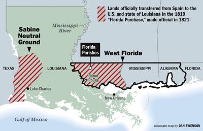
One was the top of the boot’s “toe” in the eastern corner; the other was the back of the “heel” in the state's far southwest.
Both have convoluted backstories.
West Florida
We’ll start with the eastern toe, the so-called Florida Parishes, from the Mississippi River by Baton Rouge straight east to the Pearl River. Originally the domain of the Tunica, Natchez, Houma, Bayogoula, Tangipahoa, Acolapissa and other native tribes, this area was claimed by France in 1682 and lightly settled in the early 1700s.
In 1762, France, foreseeing defeat by the British in the French and Indian War, secretly ceded to Spain everything west of the Mississippi, plus New Orleans east of the river. Defeat came in 1763, at which point all remaining French land east of the Mississippi became British, as did Spain’s Florida colony, which became British West Florida.
This put two hostile nations, Britain and Spain, on either side of Lake Pontchartrain.
Twenty years later, in 1783, the Americans defeated the British at the end of the American Revolution. Former English colonies became American, while British West Florida reverted to Spain.
Spain and the United States later agreed that the 31st parallel would form their international border, which President George Washington commissioned Andrew Ellicott to survey. “Ellicott’s Line” put the top of Louisiana’s future “toe” on the map, but at the time, it marked the upper boundary of the entire Florida panhandle.
In 1800, France, under Napoleon, pressured Spain to return Louisiana, which three years later France turned around and sold to the United States. The Louisiana Purchase put American territory on both sides of slender Spanish West Florida, which had been excluded from both deals. All this political upheaval put New Orleans and Baton Rouge under different flags — which would both change at least three times in as many decades.
The tumult would continue. Because Spanish West Florida had previously been British, it had a substantial Anglo-Saxon population, particularly around St. Francisville and Baton Rouge. Many remained antagonistic to Spanish rule, and some called for independence. In 1810, rebellious factions formed the Republic of West Florida in what is now West and East Feliciana, East Baton Rouge, St. Helena, Livingston, Tangipahoa, Washington and St. Tammany parishes.
But creating a new nation proved more that the rebels had bargained for. Within a few months, the tiny republic acquiesced to American occupation, and the Florida Parishes apparently got subsumed into the Louisiana Territory in 1810-1811 and into the state that entered the Union in 1812. Maps of the era show as much.
However, because Spain had not recognized the short-lived Republic of West Florida, it refused to transfer any land titles. American diplomats tacitly acknowledged that the destiny of Florida, and of Louisiana’s Florida Parishes, required further negotiations with Spain.
Those negotiations led to the Adams-Onís Treaty of 1819. But before we go there, let us shift out attention to the opposite end of the state — the “boot heel” in southwestern Louisiana.
The Sabine 'Neutral Ground'
This thicket of prairie and swamp between the Sabine and Calcasieu rivers had long been something of an inter-imperial mystery. Spanish authorities viewed it as the easternmost frontier of New Spain, whereas French colonials saw it as the western edge of French Louisiana.
Neither power militarized the wilderness, but both kept an eye on the other. When the French founded Natchitoches on their side in 1714, the Spanish responded a few years later by establishing Los Adaes a few miles to the west. In between was a “free state” where isolated populations of African, indigenous, Spanish and French peoples, as well as a fair number of buccaneers and rogues, made do in a space without a controlling authority.
Then came the 1762 cession of Louisiana from France to Spain, which put the entire area under Spanish rule, seemingly resolving the power vacuum.
But the problem returned after the 1800 Spanish cession back to France and Napoleon’s 1803 sale of the French lands to the United States. Now Spanish and American interests stared down each other across the “Sabine strip,” with the former understanding Mexico to extend eastward, the latter holding that Louisiana stretched westward.
Neither side wanted to make trouble with an erstwhile friend, so the two nations instead agreed in 1806 to declare the zone a “Neutral Ground,” which historian J. Villasana Haggard described as “lying between two sovereign nations but under the authority of neither.”
The Neutral Ground agreement kept the peace, but both parties knew it could only be temporary. Settlers would arrive, land would be claimed, and someone would have to govern the “Sabine Free State.” Some pro-American mapmakers went ahead and depicted the area as fully part of Louisiana upon statehood in 1812, but, as with West Florida, Spain adamantly disputed such presumptions.
Enter Luis de Onís, Spain’s envoy to the United States, and John Quincy Adams, the U.S. secretary of state. Both diplomats had border issues to clear up and were willing to negotiate. Spain sought to unburden itself of the unpromising Florida colony so that it could focus on its highly valuable but increasingly volatile empire to the south. Spain also wanted legal protection against claims filed by Americans.
The Americans wanted Florida, as well as legal clarity as to where, exactly, their Louisiana Purchase territory abutted Spanish Mexico.
In February 1819, Adams and Onís agreed to a “Treaty of Amity, Settlement, and Limits Between the United States of America and His Catholic Majesty.”
The 16-article accord called for Spain to cede to the United States “all the territories … eastward of the Mississippi, known by the name of East and West Florida [including] adjacent islands, all public lots and squares, vacant lands, public edifices, fortifications, barracks, and other buildings.”
This affirmed once and for all that the Florida Parishes were part of the United States and of the state of Louisiana. Sections of the cession east of the Pearl River were eventually divvied up among the states of Mississippi and Alabama and the territory of Florida.
The treaty also stipulated the “boundary-line between the two countries, west of the Mississippi, shall begin on the Gulph [sic] of Mexico, at the mouth of the river Sabine, in the sea, continuing north, along the western bank of that river, to the 32d degree of latitude.” This made the Sabine Neutral Ground into American land, and gave Louisiana its boot heel.
Other articles clarified the international border from Louisiana to the Pacific and addressed navigational and legal matters, with the Americans “exonerating Spain from all … claims of their citizens.” No money changed hands, but because of the exoneration clause, capped at $5 million, the Adams-Onís Treaty is sometimes called the “Florida Purchase.”
The treaty was signed on Feb. 22, 1819, and ratified to go into effect two years later. A major complication occurred in the interim: Mexico won its independence from Spain, evidencing just how volatile the Spanish empire had become. Luckily for the Americans, Mexico later affirmed the Adams-Onís Treaty.
The consequences of these shifting political geographies were enormous. Millions of lives would be affected, including those of Americans and Mexicans, for years to come. Indigenous peoples would be displaced, slavery would expand, a war of territorial expansion would be fought, and settlers would move westward.
In Louisiana, two sub-regions finally resolved their sovereignty, and settlement and development would follow with residents secure in knowing who governed them.
Vestiges of this tumultuous era persist in our landscape and in our vernacular. “Ellicott’s Line,” surveyed in 1798-1800, still traces the 31st parallel; you cross it when you drive from Kentwood to McComb on Interstate 55. Irregular British metes-and-bounds land surveys are still in place near St. Francisville, which itself looks more English than French or Spanish. Many folks still use the term “Florida Parishes” to refer to the land across Lake Pontchartrain from New Orleans.
Meanwhile, to the west, the Sabine River still separates Louisiana from Texas, though the Louisiana side feels pretty Texan, with cowboys and cattle, and the Texas side feels quite a bit like Louisiana, with Cajuns and crawfish. Folks in Florien, a small town near the Texas border, hold the Sabine Free State Festival each fall, celebrating their rustic frontier heritage.
And “neutral ground”? It’s possible our usage of that distinctive term for street medians in New Orleans derives from its coinage in the 1806 agreement with Spain. New Orleans at that time was the capital of the territory, and the “Neutral Ground” issue with Spain often came up in official papers and public discourse.
It became part of the local lexicon at a time when the local rivalry between Creoles and Anglos peaked. Most Creoles lived downtown, most Anglos lived uptown, and Canal Street, with its ample median, ran down the middle. Possibly as a jocular reference to the divisive factions on either side of the capacious boulevard, people started to refer to Canal Street’s median as a “neutral ground” by 1837, if not earlier. By the 1850s the term spread to medians citywide.
Today “neutral ground” is as much a part of our local vernacular as Louisiana’s “boot,” 200 years old this month, is a part of our iconography.
Richard Campanella, a geographer with the Tulane School of Architecture, is the author of “Cityscapes of New Orleans,” “Bienville’s Dilemma” and “Bourbon Street: A History.” He may be reached through http://richcampanella.com , rcampane@tulane.edu , or @nolacampanella on Twitter.


