There are ways, at least in theory, of stemming the tyranny of the motor car in the old cities of England, such as restricted zones and pedestrian precincts – and then there is York. The survival of this extraordinary place, dominated by the great Minster, is a secular miracle, a vindication of No Surrender by the generations safeguarding the old heart of the town and its Shambolic antigrid of lanes and passages.
If you are even faintly familiar with York, you will know that that adjective has a capital S on account of the Shambles, the long medieval lane barely wider than its pavements and overhung with upper storeys.
But first, the station, the proper gateway to such a classic railway town, one that prospered through the making and maintaining of trains. When it was built in 1877, it was the largest station in the world, with 13 platforms, and was a major crossroads linking southern England with the industrial north-east and Scotland. The place still confers an epic quality on arrivals and departures, as does the comfy bulk of the Grand Hotel. Travelling is a venerable business here.

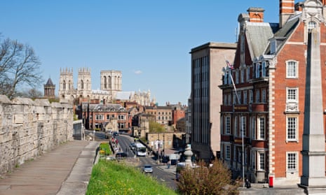
Go left down Station Road, which snakes right then left before taking you under a thin stone arch topped with railings. Immediately to your left are the beckoning steps up to the city walls. It is here that the inversion of the usual priorities begins, for you are up on a kind of pedestrian flyover, with the traffic doing its best below. Then you’re on the bridge over the Ouse, whose confluence with the Foss was as crucial to the town’s early development as the subsequent rail junction.
Into Museum Street and the view ahead is crowded with towers. First, to your left, comes the Roman Catholic Saint Wilfrid’s on Duncombe Place, all sturdy gothic revival swiftly upstaged by the great twin towers beyond. But then so is everything else, for this is York Minster, ecclesiastical capital of the settled north and seat of the archbishop who is only one down from Canterbury. It’s a whopper, the second-largest gothic cathedral in northern Europe (after Cologne), getting on for 200 metres long and more than two centuries in the building. It boasts the nation’s biggest chapter house and its East Window blazes with the world’s largest expanse of medieval stained glass.
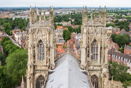
Here, as in much of the city, you walk among the mingled footprints of ministry and military. Outside, the battlements of the wall and inside, the embattlements of war: the shields of the region’s leading families – Percys, Mowbrays and Nevilles – who lent support to the Plantagenet kings in their wars against the Scots; and the astronomical clock conceived in 1944 to honour airmen who died in the second world war. The walk around it is as rewarding as the interior. This is best done by turning left off High Petergate into Precentor’s Court, then right into Dean’s Park, right again into Minster Yard, which turns into College Street. Another right turn into Deangate completes the circumnavigation and leads you back into Petergate, first High then Low.
The view now is the familiar York streetscape: a converging perspective of half-timbered buildings, homes above, shops below. Here people – yourself soon included – stroll in the middle of the streets. The absence of traffic becomes audible in the sound of church bells, and visible in the absence of metal clutter at eye level.
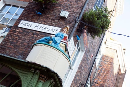
Petergate was the site of the city’s first printing press, and was for a while called Bookbinder’s Alley – hence the sculpture of Minerva with a stack of books above a shop which was the meeting place for one the country’s first book groups.
Almost unnoticed, to your right, between the frontages of York Fine Arts and Timberland, is a narrow gap leading into an alley, one of countless tiny paths known as Snickelways. To enter one is to go down a wormhole into a kind of York Profonde, all tight corners, hidden yards and unexpected connections. This particular one is Lund’s Court, formerly known as Mad Alice Lane after a woman hanged in 1823 for poisoning her husband.
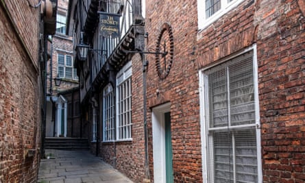
Though the word sounds as medieval as the passages, it is the 1983 coinage of local author Mark W Jones, formed of three words meaning passage: snicket, ginnel and alleyway. Influenced by Alfred Wainwright, Jones created a handwritten guide to these passages and it became a runaway, or walkaway, success.
Second only to the railway industry in importance to York was confectionery. To see how the Rowntree family shaped the city with their blend of enterprise, Quaker temperance and jobs for women, take in York’s Chocolate Story, off to your right at Kings Square. It’s less dramatic than the Jorvik Viking Centre on Coppergate, but more palatable.
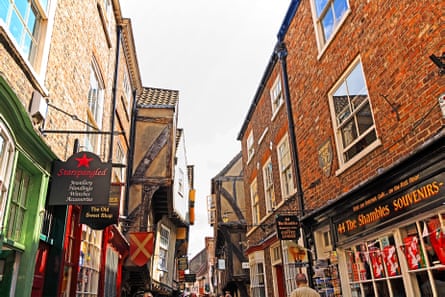
And so to the Shambles, which is no such thing, but rather an impeccably preserved market street with some buildings dating from the 14th century. Nor, it must be said, is its name unique, cropping up as it does in Chesterfield, Chippenham and Manchester to name but three more. York’s version used to be called the Great Flesh Shambles, from the Anglo-Saxon word Fleshammels, which were shelves for butchers’ meat. Some of these can still be seen outside the stylishly curated shops, even though the last butcher’s shut in 1872.

Go through the adjacent market place, trying to ignore the low-rise vandalism of the building above Thomson Travel and Greggs. Down into Pavement, left and then, at the crossroads, right into Fossgate, which humps over the river and turns into Walmgate. At the corner of St. Deny’s Road, on your right, stands the church of that name with its Norman doorway. Carry on for the full length of the street. More than a quarter of a mile but well worth the legwork as it brings you to 14th century Walmgate Bar, the city’s eastern gate. From here, you can walk the wall, or close beside it, for almost the whole way back to the station, round the old city’s southern boundary.

It’s an experience like few others: to your right the 20th century with its orderly crescents, cul-de-sacs and allocations of garden and to your left the beginnings of suburbia; but beneath your feet, putting the wall into walkway, the rampart path bears you along, over and between, with that prerogative of the overpass once more. Cross the Foss again at Tower Street, with the redoubtable Clifford’s Tower to your right on its plinth-perfect mound. Straight over the Ouse, with its grand north-easterly sweep, then the wall again, along by Nunnery Lane, then Queen Street and the proud old station, going nowhere but also everywhere.
Comments (…)
Sign in or create your Guardian account to join the discussion