Skip to content
NOWCAST 16 WAPT News First at 4
Watch on Demand
Advertisement

Cold front brings threat of severe storms to central Mississippi

Damaging winds, heavy rain and some spin-up tornadoes are possible, according to 16 WAPT meteorologists

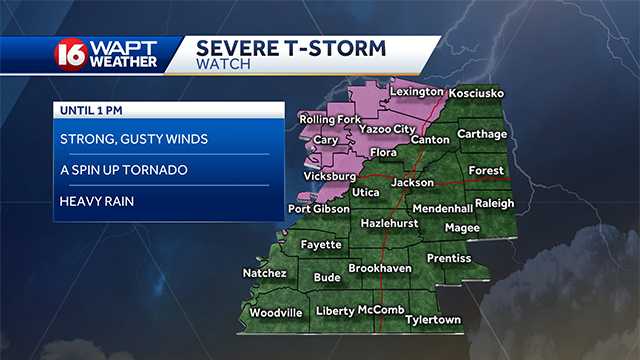
Severe Thunderstorm Watch issued for NW counties until 1pm.
Advertisement
Cold front brings threat of severe storms to central Mississippi

Damaging winds, heavy rain and some spin-up tornadoes are possible, according to 16 WAPT meteorologists

Severe weather is possible today in Central Mississippi. The threat is the result of a strong cold front that is producing the potential of severe weather in central Mississippi, according to 16 WAPT meteorologists.A line of thunderstorms, some of which could be strong to severe, will has moved into central Mississippi. The storms should exit the region between 2 p.m. and 4 p.m. Meteorologists say that the line will weaken as it moves through the central part of the state. Highest threat for spin-up tornadoes will exist across the Mississippi River counties. The main threats from these storms are damaging straight-line winds, heavy rain and the possibility of spin-up tornadoes, according to 16 WAPT meteorologists. The front and storms should move through central Mississippi quickly followed by sunny weather and cooler temperatures for Tuesday and Wednesday.Fall is a second severe weather season for Mississippi.

Severe weather is possible today in Central Mississippi.

The threat is the result of a strong cold front that is producing the potential of severe weather in central Mississippi, according to 16 WAPT meteorologists.

Advertisement

A line of thunderstorms, some of which could be strong to severe, will has moved into central Mississippi. The storms should exit the region between 2 p.m. and 4 p.m.

Meteorologists say that the line will weaken as it moves through the central part of the state. Highest threat for spin-up tornadoes will exist across the Mississippi River counties.

The main threats from these storms are damaging straight-line winds, heavy rain and the possibility of spin-up tornadoes, according to 16 WAPT meteorologists.

The front and storms should move through central Mississippi quickly followed by sunny weather and cooler temperatures for Tuesday and Wednesday.

Fall is a second severe weather season for Mississippi.